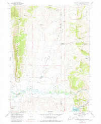
1968 Map of Woodruff Narrows
USGS Topo · Published 1980About this map
The Bear River winds through a high-elevation corridor along the Utah-Wyoming border, defined by the Crawford Mountains to the west and the Session Mountains to the east. This landscape is a complex network of water management, where the main river channel is flanked by a Canal, Ditch, and the Woodruff Narrows Reservoir. The presence of Woodruff Lower Narrows and Woodruff Upper Narrows indicates the restrictive topography that shaped local hydraulic engineering.
Find a feature on this map
49 named features on this map. Tap any name to fly to it.
Don’t see what you’re looking for? This feature index may not catch every label — zoom into the map to look around manually.
Map Details
Editions of this 1968 Woodruff Narrows Map
3 editions found
Other maps of this area

1912 · Randolph
USGS Topo · 1:125,000

1954 · Ogden
USGS Topo · 1:250,000

1958 · Ogden
USGS Topo · 1:250,000

1960 · Ogden
USGS Topo · 1:250,000

1962 · Sawtooth Mountain
USGS Topo · 1:24,000

1962 · Windy Point
USGS Topo · 1:24,000

1965 · Three Forks
USGS Topo · 1:24,000

1968 · Rex Peak
USGS Topo · 1:24,000

1968 · Randolph
USGS Topo · 1:24,000

1968 · Woodruff
USGS Topo · 1:24,000