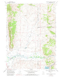
1968 Map of Woodruff Narrows
USGS Topo · Published 1980About this map
The Bear River winds through this high-altitude borderland in the late 1960s, a landscape defined by water management and ranching infrastructure. Irrigation is central to the area's geography, evidenced by an extensive network of gravity-fed channels including the Bear Canal, Booth Canal, and the Neville Ditch. These waterways support the arid Dry Flats and help sustain the livestock economy that relies on named water sources like Git Smith Spring and Warner Spring.
Find a feature on this map
48 named features on this map. Tap any name to fly to it.
Don’t see what you’re looking for? This feature index may not catch every label — zoom into the map to look around manually.
Map Details
Editions of this 1968 Woodruff Narrows Map
3 editions found
Other maps of this area

1912 · Randolph
USGS Topo · 1:125,000

1954 · Ogden
USGS Topo · 1:250,000

1958 · Ogden
USGS Topo · 1:250,000

1960 · Ogden
USGS Topo · 1:250,000

1962 · Sawtooth Mountain
USGS Topo · 1:24,000

1962 · Windy Point
USGS Topo · 1:24,000

1965 · Three Forks
USGS Topo · 1:24,000

1968 · Rex Peak
USGS Topo · 1:24,000

1968 · Randolph
USGS Topo · 1:24,000

1968 · Woodruff
USGS Topo · 1:24,000