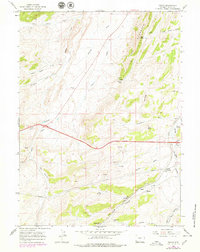
1965 Map of Ragan
USGS Topo · Published 1979About this map
The Union Pacific railroad and a network of early industrial sites define this high-country landscape in Uinta County. The map reveals the critical infrastructure of the era, from the path of the Emigrant Trail at the southern edge to the Soda Aqueduct and numerous Oil Wells. Resource extraction is prominent throughout the terrain, evidenced by the Lazeart Mine and Jakes Mine, alongside various Prospect and Drill Hole locations.
Find a feature on this map
40 named features on this map. Tap any name to fly to it.
Don’t see what you’re looking for? This feature index may not catch every label — zoom into the map to look around manually.
Map Details
Editions of this 1965 Ragan Map
3 editions found
Other maps of this area

1954 · Ogden
USGS Topo · 1:250,000

1958 · Ogden
USGS Topo · 1:250,000

1960 · Ogden
USGS Topo · 1:250,000

1965 · Bridger
USGS Topo · 1:24,000

1965 · Ragan
USGS Topo · 1:24,000

1965 · Leroy
USGS Topo · 1:24,000

1965 · Little Dee Creek
USGS Topo · 1:24,000

1965 · Meadow Draw
USGS Topo · 1:24,000

1965 · Sulphur Creek Reservoir
USGS Topo · 1:24,000
1965 · Hague Creek
USGS Topo · 1:24,000