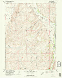
1965 Map of Millis
USGS Topo · Published 1995About this map
The Emigrant Trail cuts across this high-elevation landscape in Uinta County, following the natural path of Coyote Creek toward the Bear River valley. This 1965 survey records a terrain defined by complex drainages and historic passage, where the Stagecoach Road and Old City Ditch Road parallel older pioneer routes. The northeastern corner of the map shows the transition into the river bottoms, marked by the Bear River and local infrastructure such as the Evanston Pumping Sta. Numerous family-named hollows, including Glasscock Hollow, Knight Hollow, and Burton Hollow, offer clues to early land use and settlement patterns in this Wyoming backcountry. Modern utilities appear alongside historical features, with Aqueduct and Pipelines traversing the ridges near Rocky Hollow and Dry Hollow.
Find a feature on this map
30 named features on this map. Tap any name to fly to it.
Don’t see what you’re looking for? This feature index may not catch every label — zoom into the map to look around manually.
Map Details
Editions of this 1965 Millis Map
2 editions found
Other maps of this area

1954 · Ogden
USGS Topo · 1:250,000

1958 · Ogden
USGS Topo · 1:250,000

1960 · Ogden
USGS Topo · 1:250,000

1965 · Evanston
USGS Topo · 1:24,000

1965 · Myers Reservoir
USGS Topo · 1:24,000

1965 · Sulphur Creek Reservoir
USGS Topo · 1:24,000

1965 · Guild Hollow
USGS Topo · 1:24,000
1965 · Pine Knoll
USGS Topo · 1:24,000

1965 · Millis
USGS Topo · 1:24,000

1968 · Wahsatch
USGS Topo · 1:24,000