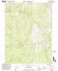
2001 Map of Woods Lake
USGS Topo · Published 2004About this map
The high-elevation divide where the Sanpete and Sevier County lines meet is defined by a series of prominent ridges and drainages within the Manti-La Sal and Fishlake National Forests. This 2001 revision highlights a landscape of significant relief, from the broad Gunnison Valley and Salina Flats to distinct peaks such as Mollys Nipple and Mount Baldy. The map documents a sophisticated network of backcountry routes, including the Great Western Trail and the Skyline Drive Trail, which follow the high crests. Water management and natural alpine features are central to the area, evidenced by high-country basins containing Woods Lake, Island Lake, and the WPA Ponds. The presence of the Whitlock Cabin and the Pinchot Trailhead Lower Arapaen TH suggests the region's enduring importance for forest administration and early conservation efforts.
Find a feature on this map
52 named features on this map. Tap any name to fly to it.
Don’t see what you’re looking for? This feature index may not catch every label — zoom into the map to look around manually.
Map Details
Editions of this 2001 Woods Lake Map
This is the sole edition of this map. No revisions or reprints were ever made.
Other maps of this area

1885 · Manti
USGS Topo · 1:250,000

1885 · Fish Lake
USGS Topo · 1:250,000

1895 · Manti
USGS Topo · 1:250,000

1896 · Fish Lake
USGS Topo · 1:250,000

1922 · Wasatch
USGS Topo · 1:31,680

1925 · Acord Lakes
USGS Topo · 1:62,500

1956 · Salina
USGS Topo · 1:250,000

1956 · Price
USGS Topo · 1:250,000

1960 · Price
USGS Topo · 1:250,000

1960 · Salina
USGS Topo · 1:250,000