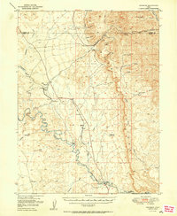
1950 Map of Woodside
USGS Topo · Published 1950About this map
The Price River winds through a landscape of deep canyons and prominent escarpments at the edge of the Carbon Co Emery Co line. Near the settlement of Woodside, the Denver and Rio Grande Western railroad serves as the primary corridor for commerce and travel, supported by the Woodside Sta and a local Po. The industrial character of the region is anchored by the Geneva Coal Mine located near Horse Canyon, reflecting the era's reliance on the coal resources of the Book Cliffs.
Find a feature on this map
36 named features on this map. Tap any name to fly to it.
Don’t see what you’re looking for? This feature index may not catch every label — zoom into the map to look around manually.
Map Details
Editions of this 1950 Woodside Map
2 editions found
Other maps of this area

1886 · Price River
USGS Topo · 1:250,000

1896 · Price River
USGS Topo · 1:250,000

1915 · Sunnyside
USGS Topo · 1:62,500

1915 · Wellington
USGS Topo · 1:62,500

1948 · Woodside
USGS Topo · 1:62,500

1949 · Woodside
USGS Topo · 1:62,500

1950 · Woodside
USGS Topo · 1:62,500

1954 · Flat Canyon
USGS Topo · 1:62,500

1954 · Range Creek
USGS Topo · 1:62,500

1956 · Price
USGS Topo · 1:250,000