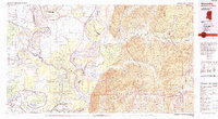
1991 Map of Woodville
USGS Topo · Published 1991About this map
Woodville sits atop the high ground of the loess bluffs, serving as a gateway between the rugged eastern timberlands and the shifting alluvial plains of the Mississippi River. This 1991 edition captures a landscape defined by water and wildlife preservation, dominated by the sprawling Homochitto National Forest to the east and a dense network of conservation areas to the west, including the Three Rivers State Wildlife Management Area and Grassy Lake State Wildlife Management Area. The river's historical volatility is evident in the complex of abandoned channels and oxbows like Larto Lake and Cocodrie Lake, while man-made engineering is represented by the Jonesville Lock and Dam and a series of landing strips. Small settlements such as Fort Adams and Pinckneyville remain tucked near the river's edge, documenting the enduring footprint of river-based commerce in Wilkinson County even as modern highways like Us 61 reorganize the region's connectivity.
Find a feature on this map
124 named features on this map. Tap any name to fly to it.
Don’t see what you’re looking for? This feature index may not catch every label — zoom into the map to look around manually.
Map Details
Editions of this 1991 Woodville Map
This is the sole edition of this map. No revisions or reprints were ever made.
Other maps of this area

1906 · Bayou Sara
USGS Topo · 1:125,000

1909 · Sycamore Landing
USGS Topo · 1:24,000

1909 · Vidalia
USGS Topo · 1:24,000

1921 · Natchez
USGS Topo · 1:48,000

1922 · Natchez
USGS Topo · 1:62,500

1935 · Tooleys
USGS Topo · 1:62,500

1936 · Woodville
USGS Topo · 1:62,500

1939 · St. Francisville
USGS Topo · 1:62,500

1939 · Red Gum
USGS Topo · 1:62,500

1939 · Natchez
USGS Topo · 1:62,500