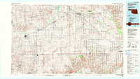
1985 Map of Woodward
USGS Topo · Published 1990About this map
Woodward stands as the regional anchor on this mid-1980s landscape, positioned near the expansive Boiling Springs State Park. The geography is defined by the broad drainage systems of the North Canadian River and the Canadian River to the south, with the Wolf Creek Valley cutting through the northwestern portion of the map. This era shows a well-established transportation network where the Atchison Topeka and Santa Fe railroad tracks parallel major routes like US Highway 60, connecting smaller agricultural hubs such as Shattuck, Gage, and Fargo.
Find a feature on this map
68 named features on this map. Tap any name to fly to it.
Don’t see what you’re looking for? This feature index may not catch every label — zoom into the map to look around manually.
Map Details
Editions of this 1985 Woodward Map
2 editions found
Other maps of this area

1954 · Perryton
USGS Topo · 1:250,000

1954 · Amarillo
USGS Topo · 1:250,000

1955 · Clinton
USGS Topo · 1:250,000

1955 · Woodward
USGS Topo · 1:250,000

1957 · Clinton
USGS Topo · 1:250,000

1958 · Perryton
USGS Topo · 1:250,000

1958 · Woodward
USGS Topo · 1:250,000

1958 · Amarillo
USGS Topo · 1:250,000

1961 · Leedey
USGS Topo · 1:62,500

1962 · Putnam
USGS Topo · 1:62,500