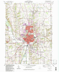
1994 Map of Wooster
USGS Topo · Published 1998About this map
The city of Wooster serves as a dense municipal and academic hub in Wayne County, centered around the College of Wooster and the Courthouse. The landscape is defined by its significant institutional presence, notably the sprawling Ohio Agricultural Research and Development Center (OARDC) to the south and the County Fairgrounds to the west. Residential growth is visible in outlying neighborhoods like Westwood and near the Wooster Plaza Shopping Center, while smaller named locales such as Madisonburg, Devil Town, and Burnetts Corners mark the surrounding township crossroads. Drainage patterns are dictated by Killbuck Creek and its tributaries, Clear Creek and Apple Creek, which carve through the terrain. The infrastructure of the mid-1990s is characterized by a mix of established city streets like Liberty St and Beall Ave, alongside newer commercial development and the industrial activity near the 3 Tracks rail corridor.
Find a feature on this map
83 named features on this map. Tap any name to fly to it.
Don’t see what you’re looking for? This feature index may not catch every label — zoom into the map to look around manually.
Map Details
Editions of this 1994 Wooster Map
This is the sole edition of this map. No revisions or reprints were ever made.
Other maps of this area

1901 · Wooster
USGS Topo · 1:62,500

1903 · Wooster
USGS Topo · 1:62,500

1906 · West Salem
USGS Topo · 1:62,500

1908 · West Salem
USGS Topo · 1:62,500

1912 · Loudonville
USGS Topo · 1:62,500

1914 · Loudonville
USGS Topo · 1:62,500

1915 · Millersburg
USGS Topo · 1:62,500

1943 · Millersburg
USGS Topo · 1:62,500

1943 · Loudonville
USGS Topo · 1:62,500

1950 · Marion
USGS Topo · 1:250,000