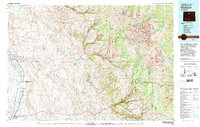
1979 Map of Worland
USGS Topo · Published 1979About this map
The Bighorn River corridor anchors the western edge of this 1970s Wyoming landscape, where the agricultural and energy industries of the Bighorn Basin meet the rising slopes of the Bighorn Mountains. The regional center of Worland serves as a hub for the surrounding ranchlands and energy developments, including the extensive Cottonwood Creek Oil and Gas Field and the Broom Creek Oil and Gas Field. To the east, the terrain transitions from the arid Wild Horse Flats to the lush drainage of the Nowood River, where the small settlement of Ten Sleep sits at the gateway to the mountains.
Find a feature on this map
84 named features on this map. Tap any name to fly to it.
Don’t see what you’re looking for? This feature index may not catch every label — zoom into the map to look around manually.
Map Details
Editions of this 1979 Worland Map
2 editions found
Other maps of this area

1895 · Dayton
USGS Topo · 1:125,000

1898 · Bald Mountain
USGS Topo · 1:125,000

1899 · Cloud peak
USGS Topo · 1:125,000

1900 · Fort McKinney
USGS Topo · 1:125,000

1901 · Cloud Peak
USGS Topo · 1:125,000

1901 · Dayton
USGS Topo · 1:125,000

1901 · Bald Mountain
USGS Topo · 1:125,000

1903 · Fort McKinney
USGS Topo · 1:125,000

1909 · Sheridan
USGS Topo · 1:125,000

1911 · Sheridan
USGS Topo · 1:125,000