
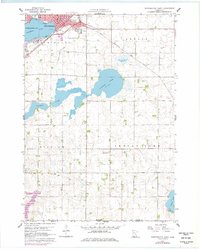
1960 Map of Worthington South
USGS Topo · Published 1962About this map
Worthington occupies the northwest corner of this prairie landscape, situated along the northern shores of Lake Okabena. The 1960 survey illustrates a regional hub defined by its transportation corridors and water management, with the Chicago and North Western and Chicago Rock Island and Pacific railroads converging near the town center. Outside the city limits, the terrain transitions into a highly managed agricultural grid, evidenced by the presence of Judicial Ditch No 6 and numerous gravel pits.
Find a feature on this map
24 named features on this map. Tap any name to fly to it.
Don’t see what you’re looking for? This feature index may not catch every label — zoom into the map to look around manually.
Map Details
Editions of this 1960 Worthington South Map
2 editions found
Other maps of this area

1954 · Fairmont
USGS Topo · 1:250,000

1958 · Fairmont
USGS Topo · 1:250,000

1960 · Brewster
USGS Topo · 1:24,000

1960 · Reading
USGS Topo · 1:24,000

1960 · Bigelow
USGS Topo · 1:24,000

1960 · Worthington North
USGS Topo · 1:24,000

1960 · Round Lake
USGS Topo · 1:24,000

1970 · Harris
USGS Topo · 1:24,000

1972 · Ocheyedan
USGS Topo · 1:24,000
1972 · Sibley East
USGS Topo · 1:24,000