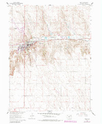
1961 Map of Wray
USGS Topo · Published 1985About this map
The town of Wray sits at a critical junction of rail and river in northeastern Colorado, serving as a regional hub for the surrounding agricultural landscape. This 1961 survey, updated with 1980s data, illustrates the settlement's relationship with the North Fork Republican River and the Burlington Northern railroad, which bisect the terrain from east to west. The surrounding plains are etched with intermittent drainage like Bloom Creek and Hages Creek, while the Haigler Canal and Olive Lake indicate the vital importance of water management in this High Plains environment. Beyond the residential grid, the map records essential infrastructure including the Wray Municipal Airport, the Wray Cem, and several Gravel Pits that reflect the local extraction industry. The presence of a Landing Strip and Sewage Disposal facility further details the town's modernization through the mid-20th century.
Find a feature on this map
21 named features on this map. Tap any name to fly to it.
Don’t see what you’re looking for? This feature index may not catch every label — zoom into the map to look around manually.
Map Details
Editions of this 1961 Wray Map
4 editions found
Other maps of this area

1954 · Limon
USGS Topo · 1:250,000

1954 · Sterling
USGS Topo · 1:250,000

1957 · Limon
USGS Topo · 1:250,000

1958 · Limon
USGS Topo · 1:250,000

1958 · Sterling
USGS Topo · 1:250,000

1961 · Robb
USGS Topo · 1:24,000

1961 · Laird
USGS Topo · 1:24,000

1961 · Wray
USGS Topo · 1:24,000

1963 · Vernon
USGS Topo · 1:24,000

1963 · Beecher Island NW
USGS Topo · 1:24,000