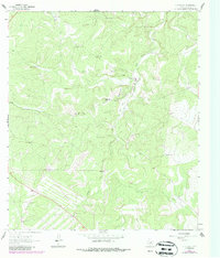
1963 Map of Y O Ranch
USGS Topo · Published 1987About this map
The Y O Ranch headquarters and surrounding hill country define this landscape, centered on the complex drainage of the Johnson Fork and Deer Park. This map reveals a specialized ranching economy dependent on a network of water sources, from the Shearing Barn Windmill to the Old Fred Pen Windmill. The terrain is marked by named summits like Gobblers Knob and isolated dwellings including the Needham House and Rincon Seco House. Modernization is evident in the mid-century additions, such as the Landing Strip and Gravel Pit, which supported the remote infrastructure of this vast Kerr County property. The distribution of numerous windmills, such as the Middle Needham Windmill and Cedar Windmill, illustrates the intensive management required to maintain livestock in this semiarid region of the Edwards Plateau.
Find a feature on this map
29 named features on this map. Tap any name to fly to it.
Don’t see what you’re looking for? This feature index may not catch every label — zoom into the map to look around manually.
Map Details
Editions of this 1963 Y O Ranch Map
2 editions found
Other maps of this area

1932 · Junction
USGS Topo · 1:62,500

1954 · Llano
USGS Topo · 1:250,000

1955 · Llano
USGS Topo · 1:250,000

1956 · Llano
USGS Topo · 1:250,000

1963 · Garven Store
USGS Topo · 1:24,000

1963 · Y O Ranch
USGS Topo · 1:24,000

1964 · Boneyard Draw
USGS Topo · 1:24,000

1964 · Live Oak Ranch
USGS Topo · 1:24,000
1971 · Earwood Creek
USGS Topo · 1:24,000
1971 · Horse Camp Waterhole
USGS Topo · 1:24,000