
1971 Map of Yacolt
USGS Topo · Published 1986About this map
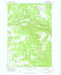
The Lewis River East Fork carves through the landscape of northeastern Clark County, creating a series of dramatic landmarks including Lucia Falls, Moulton Falls, and Salmon Falls. By the early 1970s, this area was defined by a mix of established rural settlements and evolving recreational spaces. The town of Yacolt sits in the northern valley, while Venersborg and Heisson anchor the southern agricultural and timber lands. Battle Ground State Park, centered on Battle Ground Lake, appears as a significant protected area amidst the ridges and plateaus. Genealogists will find family and local history preserved in locations like Gravel Point Cem and Finn Hill Cem, while topographic details show the transition from the flatlands of Garner Prairie to the heights of Bells Mountain. Road systems such as Worthington Rd and Chelatchie Road illustrate the network connecting these upland communities.
Find a feature on this map
43 named features on this map. Tap any name to fly to it.
Don’t see what you’re looking for? This feature index may not catch every label — zoom into the map to look around manually.
Map Details
Editions of this 1971 Yacolt Map
2 editions found
Other maps of this area

1897 · Portland
USGS Topo · 1:62,500

1905 · Portland
USGS Topo · 1:62,500

1918 · Troutdale
USGS Topo · 1:62,500

1934 · Troutdale
USGS Topo · 1:48,000

1940 · Portland
USGS Topo · 1:62,500

1940 · La Center
USGS Topo · 1:62,500

1941 · Yacolt
USGS Topo · 1:62,500

1941 · Camas
USGS Topo · 1:62,500

1942 · Camas
USGS Topo · 1:62,500

1948 · Vancouver
USGS Topo · 1:250,000