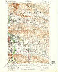
1953 Map of Yakima East
USGS Topo · Published 1958About this map
The Yakima River carves a path through the center of this landscape, separating the high desert terrain of the Yakima Firing Center Military Reservation from the growing residential and agricultural centers to the south. In the early 1950s, the region shows a distinct shift from the rugged ridges of Umtanum Ridge and Elephant Mountain toward the irrigated valley floor. Here, the Northern Pacific RR and Pacific Highway anchor settlements like Union Gap and East Selah. The map documents a sophisticated water management system necessary for the area's development, including the Moxee Canal and Wapato Canal. Local community life is evidenced by clustered institutions such as Holy Rosary Sch in Moxee City and the Pioneer Cem, providing a detailed look at the social geography of the valley during the post-war era.
Find a feature on this map
50 named features on this map. Tap any name to fly to it.
Don’t see what you’re looking for? This feature index may not catch every label — zoom into the map to look around manually.
Map Details
Editions of this 1953 Yakima East Map

Other maps of this area

1899 · Ellensburg
USGS Topo · 1:125,000

1901 · Ellensburg
USGS Topo · 1:125,000

1910 · Zillah
USGS Topo · 1:125,000

1936 · Yakima East
USGS Topo · 1:48,000

1936 · Hog Ranch Buttes
USGS Topo · 1:48,000

1937 · White Swan
USGS Topo · 1:125,000

1938 · Badger Pocket
USGS Topo · 1:48,000

1939 · Boylston
USGS Topo · 1:48,000

1941 · Black Rock Spring
USGS Topo · 1:62,500

1941 · Yakima East
USGS Topo · 1:62,500