
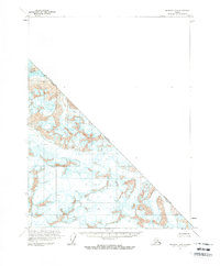
1997 Map of Yakutat B-1
USGS Topo · Published 2000About this map
The Alsek River dominates this topographical landscape, flowing through a transition of glacial ice and river valleys along the international boundary between Canada and the United States. Revised in the late 1990s using imagery from 1996, the map documents the boundaries where the Glacier Bay National Park and Wilderness meets the Tongass National Forest. These administrative lines cut across physical landmarks like the Brabazon Range and the Novatak Glacier, illustrating the complex management of this wilderness. A single Gaging Station along the river serves as one of the few indicators of human infrastructure in a region otherwise defined by natural features like the Nose. This survey provides a precise record of the City and Borough of Yakutat as it stood at the end of the 20th century.
Find a feature on this map
13 named features on this map. Tap any name to fly to it.
Don’t see what you’re looking for? This feature index may not catch every label — zoom into the map to look around manually.
Map Details
Editions of this 1997 Yakutat B-1 Map
This is the sole edition of this map. No revisions or reprints were ever made.
Other maps of this area

1951 · Yakutat
USGS Topo · 1:250,000

1952 · Skagway
USGS Topo · 1:250,000

1959 · Yakutat A-1
USGS Topo · 1:63,360

1959 · Yakutat A-2
USGS Topo · 1:63,360

1959 · Yakutat B-2
USGS Topo · 1:63,360

1959 · Yakutat B-1
USGS Topo · 1:63,360

1959 · Yakutat
USGS Topo · 1:250,000
1961 · Skagway B-8
USGS Topo · 1:63,360

1961 · Skagway A-8
USGS Topo · 1:63,360

1961 · Skagway
USGS Topo · 1:250,000