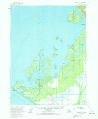
1959 Map of Yakutat C-5
USGS Topo · Published 1972About this map
Yakutat sits at the nexus of the North Pacific and the protected waters of Monti Bay, serving as a vital maritime and aviation hub for the eastern Gulf of Alaska during the mid-20th century. The settlement is anchored by infrastructure like the Yakutat Airport and a designated Seaplane Base at Shipyard Cove, reflecting its importance for regional transport. The geography is defined by a dense archipelago including Khantaak Island and Knight Island, separated by intricate passages such as Johnstone Passage and Hatchet Pass.
Find a feature on this map
56 named features on this map. Tap any name to fly to it.
Don’t see what you’re looking for? This feature index may not catch every label — zoom into the map to look around manually.
Map Details
Editions of this 1959 Yakutat C-5 Map
2 editions found
Other maps of this area

1951 · Yakutat
USGS Topo · 1:250,000

1959 · Yakutat B-5
USGS Topo · 1:63,360

1959 · Yakutat C-5
USGS Topo · 1:63,360

1959 · Yakutat D-4
USGS Topo · 1:63,360

1959 · Yakutat C-4
USGS Topo · 1:63,360

1959 · Yakutat B-4
USGS Topo · 1:63,360

1959 · Yakutat D-5
USGS Topo · 1:63,360

1959 · Yakutat
USGS Topo · 1:250,000
1985 · Yakutat D-6
USGS Topo · 1:63,360
1985 · Yakutat C-6
USGS Topo · 1:63,360