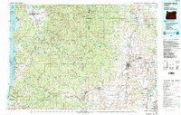
1980 Map of Yamhill River
USGS Topo · Published 1987About this map
The Yamhill River and its major southern tributary, the South Yamhill River, dominate the inland drainage of this region, flowing from the Coast Ranges toward the fertile valleys to the east. This 1980s-era study captures the landscape as it transitions from the dense timberlands of the Siuslaw National Forest and Tillamook State Forest to the agricultural reaches of Yamhill and Polk counties. In the western portion, the Pacific coastline is defined by prominent landmarks like Cape Lookout and Cape Meares, where small coastal communities like Pacific City and Netarts reside near the estuaries. Further inland, the map details the infrastructure of timber and transit, showing the Southern Pacific rail lines connecting towns such as Sheridan, Willamina, and Ballston. The presence of the Grand Ronde Agency and the Cascade Head Experimental Forest highlights the managed nature of these coastal and valley resources during the late twentieth century.
Find a feature on this map
125 named features on this map. Tap any name to fly to it.
Don’t see what you’re looking for? This feature index may not catch every label — zoom into the map to look around manually.
Map Details
Editions of this 1980 Yamhill River Map
3 editions found
Other maps of this area

1915 · Rickreall
USGS Topo · 1:31,680

1915 · Hillsboro
USGS Topo · 1:62,500

1915 · Eola
USGS Topo · 1:31,680

1916 · Tualatin
USGS Topo · 1:62,500

1917 · Salem
USGS Topo · 1:62,500

1918 · Hillsboro
USGS Topo · 1:62,500

1923 · Mount Angel
USGS Topo · 1:62,500

1924 · Mc Minnville
USGS Topo · 1:48,000

1925 · Stayton
USGS Topo · 1:62,500

1926 · Mc Minnville
USGS Topo · 1:62,500