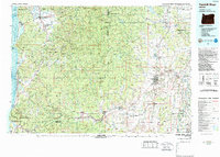
1980 Map of Yamhill River
USGS Topo · Published 1987About this map
The Yamhill River drainage and the surrounding Oregon Coast Range appear here as they were during the late 1970s and early 1980s. This survey illustrates the transition from the marine environments of Tillamook Bay and the Pacific Ocean to the agricultural heart of the Willamette Valley. Significant landmarks include the Grand Ronde Agency and the Grand Ronde Valley, alongside numerous small coastal and inland settlements like Netarts, Hemlock, and Beaver. The landscape is dominated by the massive acreage of the Tillamook State Forest and Siuslaw National Forest, reflecting the region's enduring timber and conservation legacy. Transportation patterns are clearly defined by the Southern Pacific railroad lines and the established corridors of Us 101 and Or 18. Notable geological and topographical features such as Mount Hebo, the Red Hills of Dundee, and the Wapato Lake Bed highlight the diverse terrain that shaped early development in Yamhill and Tillamook counties.
Find a feature on this map
141 named features on this map. Tap any name to fly to it.
Don’t see what you’re looking for? This feature index may not catch every label — zoom into the map to look around manually.
Map Details
Editions of this 1980 Yamhill River Map
3 editions found
Other maps of this area

1915 · Rickreall
USGS Topo · 1:31,680

1915 · Hillsboro
USGS Topo · 1:62,500

1915 · Eola
USGS Topo · 1:31,680

1916 · Tualatin
USGS Topo · 1:62,500

1917 · Salem
USGS Topo · 1:62,500

1918 · Hillsboro
USGS Topo · 1:62,500

1923 · Mount Angel
USGS Topo · 1:62,500

1924 · Mc Minnville
USGS Topo · 1:48,000

1925 · Stayton
USGS Topo · 1:62,500

1926 · Mc Minnville
USGS Topo · 1:62,500