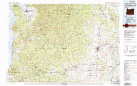
1980 Map of Yamhill River
USGS Topo · Published 1980About this map
Tillamook State Forest and the Siuslaw National Forest dominate the mountainous interior of this region, where the Yamhill River and its various forks originate. Compiled from surveys spanning several decades, the map shows the transition from the rugged timberlands and coastal outposts like Netarts and Pacific City to the agricultural expanses of the Willamette Valley. In the west, the Three Capes Scenic Route winds along a dramatic coastline featuring Cape Lookout and Cape Kiwanda State Park.
Find a feature on this map
140 named features on this map. Tap any name to fly to it.
Don’t see what you’re looking for? This feature index may not catch every label — zoom into the map to look around manually.
Map Details
Editions of this 1980 Yamhill River Map
3 editions found
Other maps of this area

1915 · Rickreall
USGS Topo · 1:31,680

1915 · Hillsboro
USGS Topo · 1:62,500

1915 · Eola
USGS Topo · 1:31,680

1916 · Tualatin
USGS Topo · 1:62,500

1917 · Salem
USGS Topo · 1:62,500

1918 · Hillsboro
USGS Topo · 1:62,500

1923 · Mount Angel
USGS Topo · 1:62,500

1924 · Mc Minnville
USGS Topo · 1:48,000

1925 · Stayton
USGS Topo · 1:62,500

1926 · Mc Minnville
USGS Topo · 1:62,500