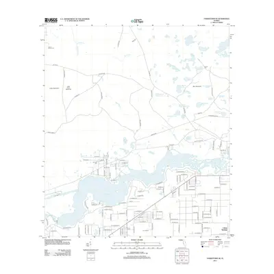
2012 Map of Yankeetown SE
USGS Topo · Published 2012About this map
Lake Rousseau and the Withlacoochee River dominate the southern half of this landscape, where the waters of the Cross Florida Barge Canal connect through a complex system of bayous and wetlands. The community of Citrus Springs is visible in the southeastern corner, showing a dense residential street grid that contrasts sharply with the forested hammocks and scattered lakes to the north. These northern regions, characterized by names like Cedar Hammock and Bear Hammock, are dotted with numerous small water bodies including Salt Sick Lake and Dog Ear Lake. Genealogists may find value in the locations of Cedar of Lebanon Cem, Robinson Cem, and Dog Ear Cem, while aviation history is represented by J.R.'s Airport. The map also traces a network of rural routes such as Old Rock Rd and SE Goethe Rd through the low-lying Florida terrain.
Find a feature on this map
131 named features on this map. Tap any name to fly to it.
Don’t see what you’re looking for? This feature index may not catch every label — zoom into the map to look around manually.
Map Details
Editions of this 2012 Yankeetown SE Map
This is the sole edition of this map. No revisions or reprints were ever made.
Other maps of this area

1892 · Dunnellon
USGS Topo · 1:62,500

1894 · Dunnellon
USGS Topo · 1:62,500

1895 · Tsala Apopka
USGS Topo · 1:62,500

1954 · Holder
USGS Topo · 1:24,000

1954 · Crystal River
USGS Topo · 1:24,000

1954 · Romeo
USGS Topo · 1:24,000

1954 · Dunnellon
USGS Topo · 1:24,000

1954 · Red Level
USGS Topo · 1:24,000

1954 · Yankeetown SE
USGS Topo · 1:24,000

1954 · Inverness
USGS Topo · 1:62,500