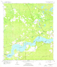
1954 Map of Yankeetown SE
USGS Topo · Published 1976About this map
Lake Rousseau and the winding Withlacoochee River dominate the southern landscape of this mid-century Florida survey, marking the watery tri-county intersection of Levy, Citrus, and Marion counties. The northern half of the map reveals a complex network of wetland features and hammocks, where the Atlantic Coast Line railroad cuts a straight line through the cypress and pine terrain. Significant for local family researchers, the map identifies small, remote burial sites including Lebanon Cem in the northwest and Dog Ear Cem near the central lakes. The naming conventions of the era are on full display through distinctive water bodies like Salt Sick Lake, Hellcat Bay, and Horse Hole Creek, illustrating how early residents navigated and identified the various pockets of the Florida backcountry before major modern development altered the drainage patterns.
Find a feature on this map
32 named features on this map. Tap any name to fly to it.
Don’t see what you’re looking for? This feature index may not catch every label — zoom into the map to look around manually.
Map Details
Editions of this 1954 Yankeetown SE Map
3 editions found
Other maps of this area

1892 · Dunnellon
USGS Topo · 1:62,500

1894 · Dunnellon
USGS Topo · 1:62,500

1895 · Tsala Apopka
USGS Topo · 1:62,500

1954 · Holder
USGS Topo · 1:24,000

1954 · Crystal River
USGS Topo · 1:24,000

1954 · Romeo
USGS Topo · 1:24,000

1954 · Dunnellon
USGS Topo · 1:24,000

1954 · Red Level
USGS Topo · 1:24,000

1954 · Yankeetown SE
USGS Topo · 1:24,000

1954 · Inverness
USGS Topo · 1:62,500