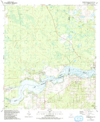
1991 Map of Yankeetown SE
USGS Topo · Published 1991About this map
Lake Rousseau and the Withlacoochee River dominate this landscape on the border of Levy, Citrus, and Marion counties. This 1991 edition captures the intricate hydraulic engineering of the region, featuring the Barge Canal, the Inglis Lock, and the Inglis Dam. The map reflects a period of residential development near the water, particularly in Citrus Springs and Crystal Manor, while preserved wetlands and hammocks like Little Cedar Hammock remain largely untouched.
Find a feature on this map
42 named features on this map. Tap any name to fly to it.
Don’t see what you’re looking for? This feature index may not catch every label — zoom into the map to look around manually.
Map Details
Editions of this 1991 Yankeetown SE Map
This is the sole edition of this map. No revisions or reprints were ever made.
Other maps of this area

1892 · Dunnellon
USGS Topo · 1:62,500

1894 · Dunnellon
USGS Topo · 1:62,500

1895 · Tsala Apopka
USGS Topo · 1:62,500

1954 · Holder
USGS Topo · 1:24,000

1954 · Crystal River
USGS Topo · 1:24,000

1954 · Romeo
USGS Topo · 1:24,000

1954 · Dunnellon
USGS Topo · 1:24,000

1954 · Red Level
USGS Topo · 1:24,000

1954 · Yankeetown SE
USGS Topo · 1:24,000

1954 · Inverness
USGS Topo · 1:62,500