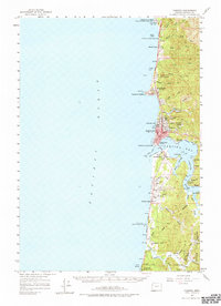
1957 Map of Yaquina NE
USGS Topo · Published 1977About this map
Newport anchors this mid-century coastal survey, situated between the Pacific Ocean and the sheltered waters of Yaquina Bay. The map documents a maritime landscape defined by its inlets and tidal sloughs, including King Slough and McCaffery Slough, which branch off the Yaquina River. Along the shore, a series of state parks and recreational landmarks appear, from the geologically distinct Devils Punch Bowl at Otter Rock down to the Coast Guard Station and Lighthouse at Yaquina Head. Moving inland, the terrain transitions into the dense timberlands of the Siuslaw National Forest. Small riverine settlements like Oysterville and Winant are visible on the eastern bank of the river, while the growth of Newport Heights and the infrastructure of the Newport Airport reflect the post-war expansion of the Lincoln County coast.
Find a feature on this map
68 named features on this map. Tap any name to fly to it.
Don’t see what you’re looking for? This feature index may not catch every label — zoom into the map to look around manually.
Map Details
Editions of this 1957 Yaquina NE Map
5 editions found

Other maps of this area

1922 · Waldport
USGS Topo · 1:62,500

1941 · Cape Foulweather
USGS Topo · 1:62,500

1942 · Euchre Mtn
USGS Topo · 1:62,500

1942 · Waldport
USGS Topo · 1:62,500

1942 · Yaquina
USGS Topo · 1:62,500

1942 · Tidewater
USGS Topo · 1:62,500

1942 · Toledo
USGS Topo · 1:62,500

1943 · Euchre Mtn
USGS Topo · 1:62,500

1944 · Cape Foulweather
USGS Topo · 1:62,500

1953 · Salem
USGS Topo · 1:250,000