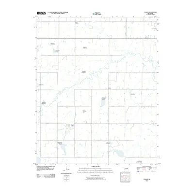
2009 Map of Yeager
USGS Topo · Published 2009About this map
Yeager serves as the central settlement on this Hughes County landscape, situated amidst a sophisticated network of flood control and water management structures. The area is defined by numerous earthen works, including the Big Wewoka Creek Site 40 Dam, Big Wewoka Creek Site 41 Dam, and Big Wewoka Creek Site 42 Dam, which regulate the tributaries of the Wewoka Creek watershed. These engineered features reflect a mid-to-late 20th-century emphasis on conservation and agricultural stability in Oklahoma's rural interior.
Find a feature on this map
26 named features on this map. Tap any name to fly to it.
Don’t see what you’re looking for? This feature index may not catch every label — zoom into the map to look around manually.
Map Details
Editions of this 2009 Yeager Map
This is the sole edition of this map. No revisions or reprints were ever made.
Other maps of this area

1900 · Wewoka
USGS Topo · 1:125,000

1954 · Oklahoma City
USGS Topo · 1:250,000

1957 · Oklahoma City
USGS Topo · 1:250,000

1963 · Oklahoma City
USGS Topo · 1:250,000

1967 · Cromwell
USGS Topo · 1:24,000

1967 · Okemah SE
USGS Topo · 1:24,000

1967 · Weleetka
USGS Topo · 1:24,000
1970 · Lamar
USGS Topo · 1:24,000
1971 · Wetumka
USGS Topo · 1:24,000
1972 · Wewoka East
USGS Topo · 1:24,000