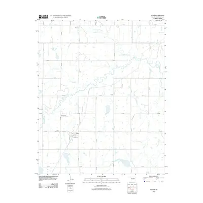
2012 Map of Yeager
USGS Topo · Published 2012About this map
Yeager serves as the primary hub of this Hughes County landscape, where the local grid of rural routes meets the winding path of Yeager Cr. The area is defined by its deep roots in the community, evidenced by several family and church burial grounds that dot the countryside. Along the banks of Wewoka Cr and its tributaries, including Little Wewoka Cr and Long George Cr, the terrain follows a natural drainage pattern that has likely influenced land use and settlement for generations.
Find a feature on this map
36 named features on this map. Tap any name to fly to it.
Don’t see what you’re looking for? This feature index may not catch every label — zoom into the map to look around manually.
Map Details
Editions of this 2012 Yeager Map
This is the sole edition of this map. No revisions or reprints were ever made.
Other maps of this area

1900 · Wewoka
USGS Topo · 1:125,000

1954 · Oklahoma City
USGS Topo · 1:250,000

1957 · Oklahoma City
USGS Topo · 1:250,000

1963 · Oklahoma City
USGS Topo · 1:250,000

1967 · Cromwell
USGS Topo · 1:24,000

1967 · Okemah SE
USGS Topo · 1:24,000

1967 · Weleetka
USGS Topo · 1:24,000
1970 · Lamar
USGS Topo · 1:24,000
1971 · Wetumka
USGS Topo · 1:24,000
1972 · Wewoka East
USGS Topo · 1:24,000