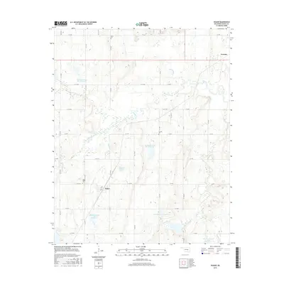
2016 Map of Yeager
USGS Topo · Published 2016About this map
Yeager and the southwestern edge of Wetumka anchor this landscape in Hughes County, Oklahoma, where the terrain is defined by an extensive network of managed water resources. The area's mid-century water management is evident in the numerous flood control structures, including Big Wewoka Creek Site 40 Reservoir, Big Wewoka Creek Site 41 Reservoir, and Big Wewoka Creek Site 42 Reservoir. These reservoirs are integrated into a drainage system carved by Wewoka Creek and its tributaries like Long George Cr and Yeager Cr. For those researching local families, the map identifies several burial grounds including Wisner Cem, Fairview Cem, and Yeager Oakhill Cem. The rural road grid, composed of routes such as N S 375 RD and E 126 RD, connects these points of interest across the creek bottoms and rising ridges.
Find a feature on this map
45 named features on this map. Tap any name to fly to it.
Don’t see what you’re looking for? This feature index may not catch every label — zoom into the map to look around manually.
Map Details
Editions of this 2016 Yeager Map
This is the sole edition of this map. No revisions or reprints were ever made.
Other maps of this area

1900 · Wewoka
USGS Topo · 1:125,000

1954 · Oklahoma City
USGS Topo · 1:250,000

1957 · Oklahoma City
USGS Topo · 1:250,000

1963 · Oklahoma City
USGS Topo · 1:250,000

1967 · Cromwell
USGS Topo · 1:24,000

1967 · Okemah SE
USGS Topo · 1:24,000

1967 · Weleetka
USGS Topo · 1:24,000
1970 · Lamar
USGS Topo · 1:24,000
1971 · Wetumka
USGS Topo · 1:24,000
1972 · Wewoka East
USGS Topo · 1:24,000