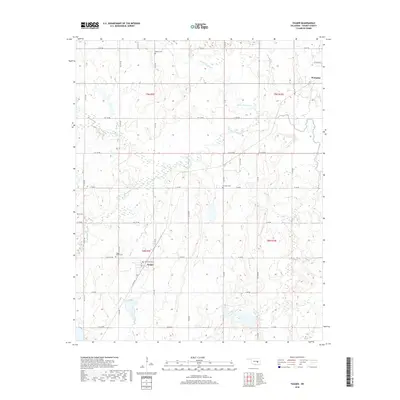
2018 Map of Yeager
USGS Topo · Published 2018About this map
Wetumka and the small community of Yeager occupy this portion of Hughes County, showing a landscape defined by a dense network of creek drainages and section-line roads. The topography is shaped by the winding courses of Little Wewoka Cr and Wewoka Creek, which are fed by numerous tributaries including Long George Cr and Yeager Cr. This drainage system creates a complex pattern of wetlands and low-lying areas across the townships.
Find a feature on this map
40 named features on this map. Tap any name to fly to it.
Don’t see what you’re looking for? This feature index may not catch every label — zoom into the map to look around manually.
Map Details
Editions of this 2018 Yeager Map
This is the sole edition of this map. No revisions or reprints were ever made.
Other maps of this area

1900 · Wewoka
USGS Topo · 1:125,000

1954 · Oklahoma City
USGS Topo · 1:250,000

1957 · Oklahoma City
USGS Topo · 1:250,000

1963 · Oklahoma City
USGS Topo · 1:250,000

1967 · Cromwell
USGS Topo · 1:24,000

1967 · Okemah SE
USGS Topo · 1:24,000

1967 · Weleetka
USGS Topo · 1:24,000
1970 · Lamar
USGS Topo · 1:24,000
1971 · Wetumka
USGS Topo · 1:24,000
1972 · Wewoka East
USGS Topo · 1:24,000