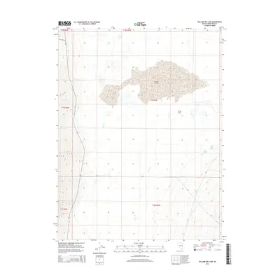
2014 Map of Yelland Dry Lake
USGS Topo · Published 2014About this map
Yelland Dry Lake dominates the central basin of this high-altitude landscape in Spring Valley, Nevada. The 2014 survey reveals an arid environment defined by seasonal hydrology, where numerous ephemeral watercourses descend from the surrounding peaks toward the dry lake bed. Notable drainages including McCoy Cr, Ranger Cr, and Vipont Cr cut through the western slopes, while North Millick Spring and South Millick Spring provide rare perennial water sources on the eastern edge of the valley. Local transportation is limited to established routes like McCoy Creek Rd and various county roads such as CR-36 and CR-37. The presence of small, isolated bodies of water like Taft Lake suggests the fragile balance of moisture in this Great Basin terrain.
Find a feature on this map
22 named features on this map. Tap any name to fly to it.
Don’t see what you’re looking for? This feature index may not catch every label — zoom into the map to look around manually.
Map Details
Editions of this 2014 Yelland Dry Lake Map
This is the sole edition of this map. No revisions or reprints were ever made.
Other maps of this area

1952 · Ely
USGS Topo · 1:125,000

1956 · Ely
USGS Topo · 1:250,000

1959 · Ely
USGS Topo · 1:250,000

1959 · Sacramento Pass
USGS Topo · 1:62,500

1959 · Connors Pass
USGS Topo · 1:62,500

1959 · Schell Peaks
USGS Topo · 1:62,500

1963 · Ely
USGS Topo · 1:250,000

1981 · North Schell Peak
USGS Topo · 1:24,000
1981 · South Schell Peak
USGS Topo · 1:24,000
1981 · Cave Mountain
USGS Topo · 1:24,000