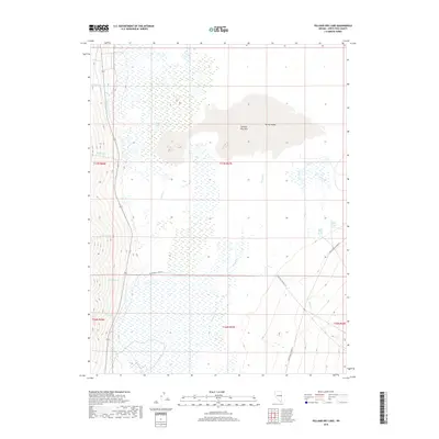
2018 Map of Yelland Dry Lake
USGS Topo · Published 2018About this map
Yelland Dry Lake sits as the central feature of this high-desert basin in Spring Valley, where the drainage patterns of White Pine County converge in a broad, arid expanse. The landscape is defined by the seasonal movement of water, with numerous creeks such as McCoy Cr, O'Toole Cr, and Vipont Cr descending from the higher elevations to the west. On the eastern edge of the valley, the presence of North Millick Spring and South Millick Spring indicates the critical groundwater sources that have long dictated movement and land use in this part of Nevada. While much of the quadrangle is dominated by the dry lake bed and intermittent wetlands, local routes like White Pine Co Road 36 provide the primary access through this remote terrain, following the natural contours of the valley floor between the mountain ranges.
Find a feature on this map
20 named features on this map. Tap any name to fly to it.
Don’t see what you’re looking for? This feature index may not catch every label — zoom into the map to look around manually.
Map Details
Editions of this 2018 Yelland Dry Lake Map
This is the sole edition of this map. No revisions or reprints were ever made.
Other maps of this area

1952 · Ely
USGS Topo · 1:125,000

1956 · Ely
USGS Topo · 1:250,000

1959 · Ely
USGS Topo · 1:250,000

1959 · Sacramento Pass
USGS Topo · 1:62,500

1959 · Connors Pass
USGS Topo · 1:62,500

1959 · Schell Peaks
USGS Topo · 1:62,500

1963 · Ely
USGS Topo · 1:250,000

1981 · North Schell Peak
USGS Topo · 1:24,000
1981 · South Schell Peak
USGS Topo · 1:24,000
1981 · Cave Mountain
USGS Topo · 1:24,000