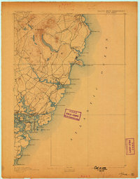
1893 Map of York
USGS Topo · Published 1898About this map
Mt. Agamenticus anchors the interior of this coastal survey, rising above a landscape of cedar swamps and small ponds like Folly Pond and Hooker Pond. Along the shore, the maritime economy of the late 19th century is evident in the cluster of post offices and light stations that protected the seafaring traffic of the Atlantic Ocean. The detailed coastline reveals the intricate geology of Bald Head Cliff and the complex tidal inlets of York Harbor and Portsmouth Harbor. While the northern reaches near Ogunquit show more dispersed settlement, the southern portion is dense with activity around the Navy Yard and Kittery. Inland, the road network connects established hamlets like York Village, York Corner, and Scotland, following the winding path of the York River. This document preserves the footprint of a region balanced between its ancient village centers and its growing role as a destination at York Beach.
Find a feature on this map
57 named features on this map. Tap any name to fly to it.
Don’t see what you’re looking for? This feature index may not catch every label — zoom into the map to look around manually.
Map Details
Editions of this 1893 York Map
5 editions found
Other maps of this area

1888 · Newburyport
USGS Topo · 1:62,500

1890 · Newburyport
USGS Topo · 1:62,500

1891 · Biddeford
USGS Topo · 1:62,500

1891 · Berwick
USGS Topo · 1:62,500

1891 · Kennebunk
USGS Topo · 1:62,500

1893 · Kennebunk
USGS Topo · 1:62,500

1893 · Dover
USGS Topo · 1:62,500

1893 · Berwick
USGS Topo · 1:62,500

1893 · York
USGS Topo · 1:62,500

1893 · Biddeford
USGS Topo · 1:62,500