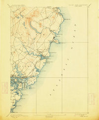
1893 Map of York
USGS Topo · Published 1913About this map
Mt Agamenticus and the surrounding high ground of York County dominate this coastal survey, offering a look at the Maine shoreline before the mid-century surge of modern development. The landscape is defined by the winding course of the York River and the complex salt marshes and tidal inlets around Kittery Point and Gerrish's Island. Maritime activity is the lifeblood of the region, evidenced by the strategic placement of The Nubble Light and Portsmouth Light, alongside the significant footprint of the Navy Yard on Seavy's Island.
Find a feature on this map
56 named features on this map. Tap any name to fly to it.
Don’t see what you’re looking for? This feature index may not catch every label — zoom into the map to look around manually.
Map Details
Editions of this 1893 York Map
5 editions found
Other maps of this area

1888 · Newburyport
USGS Topo · 1:62,500

1890 · Newburyport
USGS Topo · 1:62,500

1891 · Biddeford
USGS Topo · 1:62,500

1891 · Berwick
USGS Topo · 1:62,500

1891 · Kennebunk
USGS Topo · 1:62,500

1893 · Kennebunk
USGS Topo · 1:62,500

1893 · Dover
USGS Topo · 1:62,500

1893 · Berwick
USGS Topo · 1:62,500

1893 · York
USGS Topo · 1:62,500

1893 · Biddeford
USGS Topo · 1:62,500