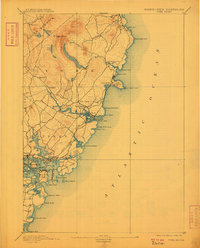
1893 Map of York
USGS Topo · Published 1909About this map
The coastal landscape of Southern Maine is defined here by its jagged shoreline and early maritime infrastructure, surveyed just before the end of the 19th century. Marine navigation is central to the area, anchored by The Nubble Light at Cape Neddick, alongside the Portsmouth Light and Whale's Back Light further south. The Navy Yard occupies a prominent position on the shoreline of Portsmouth Harbor, signaling the long-standing military and industrial importance of the Piscataqua River mouth.
Find a feature on this map
57 named features on this map. Tap any name to fly to it.
Don’t see what you’re looking for? This feature index may not catch every label — zoom into the map to look around manually.
Map Details
Editions of this 1893 York Map
5 editions found
Other maps of this area

1888 · Newburyport
USGS Topo · 1:62,500

1890 · Newburyport
USGS Topo · 1:62,500

1891 · Biddeford
USGS Topo · 1:62,500

1891 · Berwick
USGS Topo · 1:62,500

1891 · Kennebunk
USGS Topo · 1:62,500

1893 · Kennebunk
USGS Topo · 1:62,500

1893 · Dover
USGS Topo · 1:62,500

1893 · Berwick
USGS Topo · 1:62,500

1893 · York
USGS Topo · 1:62,500

1893 · Biddeford
USGS Topo · 1:62,500