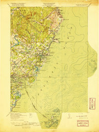
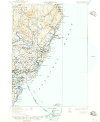
1920 Map of York
USGS Topo · Published 1920About this map
York Village and Kittery anchor this coastal survey, where the Atlantic shoreline meets the intricate tidal inlets of the York River and Piscataqua River. The landscape is defined by its maritime economy and early 20th-century transportation networks, notably the Atlantic Shore Electric Railway that connected coastal communities like York Beach and Oceanside. Far offshore, the Boon Island L.H. and the Isles of Shoals L.H. stand as critical navigational markers for the seafaring trade entering Portsmouth Harbor.
Find a feature on this map
130 named features on this map. Tap any name to fly to it.
Don’t see what you’re looking for? This feature index may not catch every label — zoom into the map to look around manually.
Map Details
Editions of this 1920 York Map
6 editions found

Other maps of this area

1888 · Newburyport
USGS Topo · 1:62,500

1890 · Newburyport
USGS Topo · 1:62,500

1891 · Biddeford
USGS Topo · 1:62,500

1891 · Berwick
USGS Topo · 1:62,500

1891 · Kennebunk
USGS Topo · 1:62,500

1893 · Kennebunk
USGS Topo · 1:62,500

1893 · Dover
USGS Topo · 1:62,500

1893 · Berwick
USGS Topo · 1:62,500

1893 · York
USGS Topo · 1:62,500

1893 · Biddeford
USGS Topo · 1:62,500