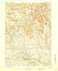
1907 Map of Younts Peak
USGS Topo · Published 1927About this map
Younts Peak stands as the dramatic focus of this high-country survey, marking the headwaters of the Yellowstone River and the Wind River systems. Mapping by surveyors like Frank Tweedy and R.B. Robertson reveals a landscape defined by the Continental Divide, where glacier-carved features like the Du Noir Glacier and Natural Bridge punctuate the high plateaus. The human footprint in this era consists primarily of isolated outposts such as Dundee Camp and a network of homesteads along the river valleys, including Kisingers Ranch and Stagner's Ranch. Near the settlement of Dubois, early industrial efforts are visible at the Sawmill and the Clarks Placer Mines, while landmarks like Welty's Hall suggest the burgeoning social fabric of the Wind River valley during the early twentieth century.
Find a feature on this map
134 named features on this map. Tap any name to fly to it.
Don’t see what you’re looking for? This feature index may not catch every label — zoom into the map to look around manually.
Map Details
Editions of this 1907 Younts Peak Map
3 editions found

Other maps of this area

1885 · Lake
USGS Topo · 1:125,000

1893 · Ishawooa
USGS Topo · 1:125,000

1895 · Ishawooa
USGS Topo · 1:125,000

1895 · Lake
USGS Topo · 1:125,000

1896 · Lake
USGS Topo · 1:125,000

1899 · Ishawooa
USGS Topo · 1:125,000

1901 · Lake
USGS Topo · 1:125,000

1902 · Mt Leidy
USGS Topo · 1:125,000

1904 · Kirwin
USGS Topo · 1:125,000

1905 · Younts Peak
USGS Topo · 1:125,000