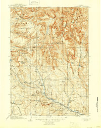
1907 Map of Younts Peak
USGS Topo · Published 1946About this map
Dubois and the surrounding high-altitude cattle ranges are meticulously documented in this 1905 survey, showing a landscape defined by isolated homesteads and early extraction industries. The settlement at Dubois is anchored by Welty's Hall, while the broader terrain is dotted with early ranches such as the Rocking Chair Ranch and Houghs Ranch. Local industry is represented by the Sawmill and the Clarks Placer Mines near the Wind River. This map reveals a rare look at the upper reaches of the Yellowstone River and the Buffalo Fork before the establishment of modern infrastructure. Geological curiosities are noted throughout, including the Old Geysers and a Natural Bridge, alongside the formidable Continental Divide. The presence of the Du Noir Glacier and numerous high peaks like Younts Peak underscores the wilderness character of the area prior to later administrative shifts.
Find a feature on this map
123 named features on this map. Tap any name to fly to it.
Don’t see what you’re looking for? This feature index may not catch every label — zoom into the map to look around manually.
Map Details
Editions of this 1907 Younts Peak Map
3 editions found

Other maps of this area

1885 · Lake
USGS Topo · 1:125,000

1893 · Ishawooa
USGS Topo · 1:125,000

1895 · Ishawooa
USGS Topo · 1:125,000

1895 · Lake
USGS Topo · 1:125,000

1896 · Lake
USGS Topo · 1:125,000

1899 · Ishawooa
USGS Topo · 1:125,000

1901 · Lake
USGS Topo · 1:125,000

1902 · Mt Leidy
USGS Topo · 1:125,000

1904 · Kirwin
USGS Topo · 1:125,000

1905 · Younts Peak
USGS Topo · 1:125,000