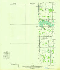
1936 Map of Ypsilanti East
USGS Topo · Published 1936About this map
Belleville Lake dominates the landscape of this 1930s borderland between Washtenaw and Wayne Counties. This advance sheet, compiled from aerial photographs, reveals an intricate drainage network essential to the region's agricultural productivity, featuring the Brown and Rounds Drain, Throop No 1 Drain, and Reynolds Drain. Small residential clusters and family-named points like Hanshaw, Jewett, and Edgewater Heights appear alongside established rural landmarks such as Soop Cem and the Willow Run Sch. The presence of the Day and Bird Marsh and Swan Creek in the south illustrates the natural hydrology before extensive modern development. This survey provides a precise record of the land just as the Willow Run area was beginning to transition from quiet rural acreage toward its significant industrial future.
Find a feature on this map
39 named features on this map. Tap any name to fly to it.
Don’t see what you’re looking for? This feature index may not catch every label — zoom into the map to look around manually.
Map Details
Editions of this 1936 Ypsilanti East Map
This is the sole edition of this map. No revisions or reprints were ever made.
Other maps of this area

1902 · South Lyon
USGS Topo · 1:62,500

1902 · Ypsilanti
USGS Topo · 1:62,500

1904 · Ann Arbor
USGS Topo · 1:125,000

1905 · Wayne
USGS Topo · 1:62,500

1906 · Ypsilanti
USGS Topo · 1:62,500

1906 · South Lyon
USGS Topo · 1:62,500

1906 · Romulus
USGS Topo · 1:62,500

1908 · Ann Arbor
USGS Topo · 1:125,000

1912 · Wayne
USGS Topo · 1:62,500

1928 · Romulus
USGS Topo · 1:62,500
Featured Places
- Ypsilanti Charter Township, MI
- Van Buren Charter Township, MI
- Ypsilanti, MI
- Sumpter Township, MI
- Augusta Charter Township, MI