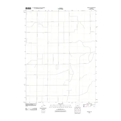
2010 Map of Yuma NE
USGS Topo · Published 2010About this map
The High Plains of northeast Colorado are defined here by a precise, rhythmic grid of agricultural transport routes established by the County Rd 46 and County Rd M corridors. This landscape in Yuma County reflects the enduring legacy of the Public Land Survey System, where section lines dictate the placement of roads such as County Rd 44 and County Rd P. While the terrain appears largely open, the network of gravel and improved roads including County Rd 42 and County Rd 40 reveals a highly organized approach to rural land management. The systematic numbering of routes like County Rd N 5/10 suggests the careful division of farmsteads and ranch land at the turn of the 21st century, illustrating how human geography and infrastructure have adapted to the expansive, flat horizons of the American West.
Find a feature on this map
16 named features on this map. Tap any name to fly to it.
Don’t see what you’re looking for? This feature index may not catch every label — zoom into the map to look around manually.
Map Details
Editions of this 2010 Yuma NE Map
This is the sole edition of this map. No revisions or reprints were ever made.
Other maps of this area

1954 · Sterling
USGS Topo · 1:250,000

1958 · Sterling
USGS Topo · 1:250,000

1961 · Eckley
USGS Topo · 1:24,000

1969 · Schramm
USGS Topo · 1:24,000

1971 · Yuma NE
USGS Topo · 1:24,000

1971 · Clarkville SE
USGS Topo · 1:24,000

1971 · Old Baldy
USGS Topo · 1:24,000
1971 · Eckley NW
USGS Topo · 1:24,000

1972 · Clarkville SW
USGS Topo · 1:24,000

1972 · Yuma South
USGS Topo · 1:24,000