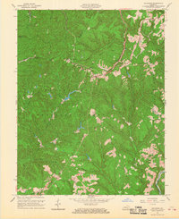
1966 Map of Zachariah
USGS Topo · Published 1968About this map
Daniel Boone National Forest dominates the landscape of this 1960s survey, where the convergence of Lee, Wolfe, Estill, and Powell counties meets the Cumberland Plateau's deeply dissected topography. The map records a rural economy rooted in natural resources, clearly identifying an active Oil Field alongside scattered ridge-top and hollow settlements. Communities like Zachariah and Torrent are joined by several religious and family landmarks, including Hopewell Ch, Bethlehem Ch, and the Townsend Cem.
Find a feature on this map
38 named features on this map. Tap any name to fly to it.
Don’t see what you’re looking for? This feature index may not catch every label — zoom into the map to look around manually.
Map Details
Editions of this 1966 Zachariah Map
2 editions found
Other maps of this area

1892 · Beattyville
USGS Topo · 1:125,000

1951 · Pomeroyton
USGS Topo · 1:24,000

1952 · Stanton
USGS Topo · 1:24,000

1952 · Slade
USGS Topo · 1:24,000

1952 · Tallega
USGS Topo · 1:24,000

1952 · Beattyville
USGS Topo · 1:24,000

1952 · Cobhill
USGS Topo · 1:24,000
1952 · Campton
USGS Topo · 1:24,000

1952 · Heidelberg
USGS Topo · 1:24,000

1953 · Zachariah
USGS Topo · 1:24,000