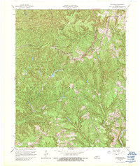
1966 Map of Zachariah
USGS Topo · Published 1988About this map
The Daniel Boone National Forest dominates this mid-1960s survey of the Kentucky Highlands, a region defined by deeply incised creek valleys and narrow ridges. Settlement patterns here follow the winding watercourses and high ground, with communities like Zachariah and Torrent serving as anchor points in a landscape carved by the Kentucky River North Fork. The map records several small upland settlements, including Standing Rock, Fixer, and Rogers, alongside rural social centers like Mt Olive Ch and Hopewell Ch. An interesting local detail is the colorful nomenclature of the terrain, specifically Hell For Certain Creek and Hell Creek, which reflects the difficulty of navigating this complex topography. Genealogists can also trace the Mt Paran Sch and numerous unnamed Cem sites scattered across the ridges of Big Bend Ridge and Big Andy Ridge.
Find a feature on this map
39 named features on this map. Tap any name to fly to it.
Don’t see what you’re looking for? This feature index may not catch every label — zoom into the map to look around manually.
Map Details
Editions of this 1966 Zachariah Map
2 editions found
Other maps of this area

1892 · Beattyville
USGS Topo · 1:125,000

1951 · Pomeroyton
USGS Topo · 1:24,000

1952 · Stanton
USGS Topo · 1:24,000

1952 · Slade
USGS Topo · 1:24,000

1952 · Tallega
USGS Topo · 1:24,000

1952 · Beattyville
USGS Topo · 1:24,000

1952 · Cobhill
USGS Topo · 1:24,000
1952 · Campton
USGS Topo · 1:24,000

1952 · Heidelberg
USGS Topo · 1:24,000

1953 · Zachariah
USGS Topo · 1:24,000