
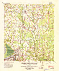
1939 Map of Zachary
USGS Topo · Published 1941About this map
Leland College and the growing rail towns of East Baton Rouge Parish define this 1939 survey, which captures the region just before mid-century expansion. The Illinois Central Railroad and Yazoo and Mississippi Valley Railroad corridors serve as the primary axes for settlements like Zachary, Baker, and Slaughter. This network supported a rural economy transitioning toward industrialization, evidenced by the oil reserve pits and the industrial activity near Scotlandville.
Find a feature on this map
69 named features on this map. Tap any name to fly to it.
Don’t see what you’re looking for? This feature index may not catch every label — zoom into the map to look around manually.
Map Details
Editions of this 1939 Zachary Map
2 editions found
Other maps of this area

1906 · Bayou Sara
USGS Topo · 1:125,000

1908 · Baton Rouge
USGS Topo · 1:62,500

1934 · Denham Springs
USGS Topo · 1:62,500

1939 · St. Francisville
USGS Topo · 1:62,500

1939 · Denham Springs
USGS Topo · 1:62,500

1939 · Baton Rouge
USGS Topo · 1:62,500

1940 · Grosse Tete
USGS Topo · 1:62,500

1942 · Pride
USGS Topo · 1:31,680

1942 · Watson
USGS Topo · 1:31,680

1945 · Jackson
USGS Topo · 1:31,680