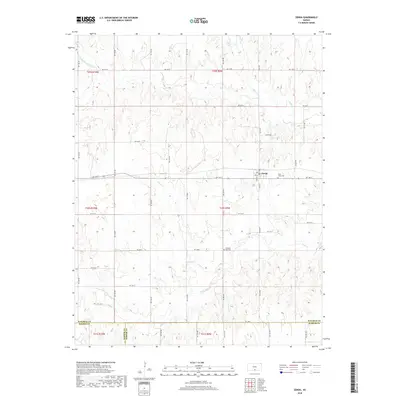
2018 Map of Zenda
USGS Topo · Published 2018About this map
Zenda sits at the heart of this agricultural landscape in southwestern Kansas, serving as a primary hub for the surrounding township. The settlement is organized around a grid of streets including S Main St and Pine St, while the outlying areas are defined by a strict section-line road network. To the east of the town center lies Saint Johns Cem, a significant site for local genealogical research. The terrain is marked by the drainage systems of the N Fork Chikaskia River, which cuts across the northwest corner, and various tributaries like Goose Cr and Sand Cr. Near the southern border with Barber County, the Pleasant Hill Cem provides another anchor for family history within this rural prairie environment.
Find a feature on this map
47 named features on this map. Tap any name to fly to it.
Don’t see what you’re looking for? This feature index may not catch every label — zoom into the map to look around manually.
Map Details
Editions of this 2018 Zenda Map
This is the sole edition of this map. No revisions or reprints were ever made.
Other maps of this area

1889 · Anthony
USGS Topo · 1:125,000

1891 · Anthony
USGS Topo · 1:125,000

1892 · Kingman
USGS Topo · 1:125,000

1894 · Kingman
USGS Topo · 1:125,000

1955 · Pratt
USGS Topo · 1:250,000

1959 · Pratt
USGS Topo · 1:250,000
1966 · St Leo
USGS Topo · 1:24,000

1967 · Cleveland
USGS Topo · 1:24,000
1967 · Willowdale
USGS Topo · 1:24,000
1973 · Spivey
USGS Topo · 1:24,000