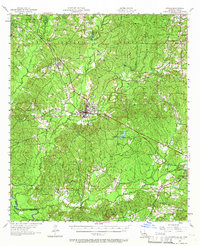
1957 Map of Zwolle
USGS Topo · Published 1966About this map
The Kansas City Southern Ry serves as a central spine through Sabine Parish, connecting the town of Zwolle with the village of Noble. This landscape is defined by the transition from upland pine forests, including sections of the Sabine National Forest, to the winding bottomlands of Bayou La Nana and Bayou San Miguel. The presence of several oil wells in the northwest, near San Patricio Ch, indicates the mid-century energy production that shaped the local economy. Genealogists will find a cluster of rural community centers, from Belmont in the northeast to the Mt Olive Cem and Recknor Cem. The terrain is punctuated by landmarks of forest management, notably the Blue Lake Lookout Tower and the Short Tree Lookout Tower, which surveyed the dense timber and the clearing at Prairie.
Find a feature on this map
36 named features on this map. Tap any name to fly to it.
Don’t see what you’re looking for? This feature index may not catch every label — zoom into the map to look around manually.
Map Details
Editions of this 1957 Zwolle Map
4 editions found
Other maps of this area

1938 · Hollis Creek
USGS Topo · 1:31,680

1941 · Zwolle
USGS Topo · 1:62,500

1941 · Pelican
USGS Topo · 1:62,500

1942 · Many
USGS Topo · 1:62,500

1942 · Florien
USGS Topo · 1:62,500

1943 · Many
USGS Topo · 1:62,500

1943 · Pleasant Hill
USGS Topo · 1:62,500

1944 · Negreet
USGS Topo · 1:62,500

1944 · Logansport
USGS Topo · 1:62,500

1944 · Patroon
USGS Topo · 1:62,500