1940s Maps of Aleutians East, Alaska
Explore 6 historic maps of Aleutians East from the 1940s. These maps offer a rare glimpse into what life looked like during the 1940s — showing old roads, neighborhoods, homes, and landmarks that have changed or disappeared over time.
Whether you're researching your family's past, planning a metal detecting trip, or studying how Aleutians East's landscape evolved across the 1940s, these high-resolution maps are a powerful tool for exploring the history of this region.
- Focus on a specific era: All maps on this page are from the 1940s, giving you a focused view of this time period.
- See what’s changed: Compare century-old streets, trails, and buildings to today's modern landscape using overlays and satellite layers.
- Research with precision: Use these maps for genealogy, historical research, land use analysis, or educational projects.
- View, download, or print: Maps are fully viewable online in high resolution, and can be downloaded or printed for your own records.
Start exploring Aleutians East's history through authentic maps from the 1940s. This is your window into the past.
Aleutians East, AK maps
(6)- 1943 Map of Fort Randall, 1954 Print
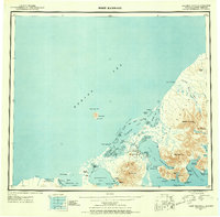 1943 Fort Randall1954 Print · USGSThe Alaska Peninsula and its wartime outposts are documented in this mid-forties survey. Researchers can trace the military footprint at Thornbrough Air Force Base and maritime hubs like King Cove and Belkofski.7 unique versions available
 - 1944 Map of Cold Bay Sheet No. 20 of 25
 1944 Cold Bay Sheet No. 20 of 251944 Print · USGSThe southwestern tip of the Alaska Peninsula is documented here during the wartime mobilization of the mid-forties. Researchers can trace the steep coastal terrain and offshore features like Amagat Island, Cape Tachilni, and the peaks around Morzhovoi Bay.
 - 1944 Map of Cold Bay Sheet No. 1 of 25
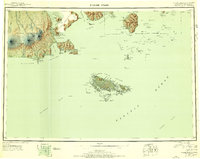
 1944 Cold Bay Sheet No. 1 of 251944 Print · USGSThe Aleutian coast comes into focus during the mid-forties as military engineers charted the strategic waters of the North Pacific. Researchers can trace the complex shoreline of Opperl Island where the Bering Sea meets the tides of Izembek Bay.
 - 1944 Map of Cold Bay Sheet No. 2 of 25
 1944 Cold Bay Sheet No. 2 of 251944 Print · USGSThe Alaska Peninsula's coastal terrain during the Aleutian Islands Campaign is meticulously recorded in this wartime survey. Genealogists and researchers can trace the shoreline of Moffet Bay and locate landmarks like Neumann Island and Moffet Point.
 - 1949 Map of False Pass, 1956 Print
 1949 False Pass1956 Print · USGSThe Aleutian landscape at the end of the 1940s is defined by the vital maritime passage between the Bering Sea and Pacific. Genealogists and researchers can trace remote coastal settlements at False Pass and Morzhovoi, or locate landmarks like Shishaldin Volcano and Sanak Harbor.6 unique versions available
 - 1949 Map of Fort Randall, 1958 Print
 1949 Fort Randall1958 Print · USGSThe southern Alaska Peninsula and the entrance to the Aleutians are documented here during the late 1940s. Researchers can trace remote coastal outposts like Belkofski, locate the Air Force Base at Fort Randall, and find the abandoned cannery at Morzhovoi Bay.
End of results
Showing maps 1-6 of 6
Top cities of Aleutians East
Frequently asked questions
- What are the different types of historical maps available for Aleutians East?
- What is the oldest map of Aleutians East?
- Where can I purchase historical maps of Aleutians East for my home or office?
- Where can I download high-res historical maps of Aleutians East?
- Are there historical topographic maps available for Aleutians East?
- Is there historical aerial imagery available for Aleutians East?
- Where are historical maps of Aleutians East sourced from?