1990s Maps of Graham County, Arizona
Explore 44 historic maps of Graham County from the 1990s. These maps offer a rare glimpse into what life looked like during the 1990s — showing old roads, neighborhoods, homes, and landmarks that have changed or disappeared over time.
Whether you're researching your family's past, planning a metal detecting trip, or studying how Graham County's landscape evolved across the 1990s, these high-resolution maps are a powerful tool for exploring the history of this region.
- Focus on a specific era: All maps on this page are from the 1990s, giving you a focused view of this time period.
- See what’s changed: Compare century-old streets, trails, and buildings to today's modern landscape using overlays and satellite layers.
- Research with precision: Use these maps for genealogy, historical research, land use analysis, or educational projects.
- View, download, or print: Maps are fully viewable online in high resolution, and can be downloaded or printed for your own records.
Start exploring Graham County's history through authentic maps from the 1990s. This is your window into the past.
Graham County, AZ maps
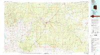
(44)- 1991 Map of Baldy Bill Point
 1991 Baldy Bill Point1991 Print · USGSGreenlee County's high wilderness terrain is captured here in the early 1990s, revealing a landscape of steep canyons and forest lookouts. Researchers can trace remote landmarks like Saunders Cabin, the cascading Chitty Falls, and the high peak at Baldy Bill Point.
 - 1991 Map of Hoodoo Knoll
 1991 Hoodoo Knoll1991 Print · USGSEastern Arizona’s high country in the early nineties is defined here by the winding Black River and the high peaks of the Bear Wallow Wilderness. Researchers can trace remote routes like the Wallow Pack Trail and locate family-named landmarks such as McKibbins Pond.
 - 1992 Map of Seneca, 1993 Print
 1992 Seneca1993 Print · USGSGila County in the early nineties remains a wild landscape of tribal reservations and national forest. Researchers can trace historic mining at the Old Owen McMillenville Mine, locate the remote settlement of Cibecue, and map the rugged drainages of the Salt River.2 unique versions available
 - 1994 Map of Willcox
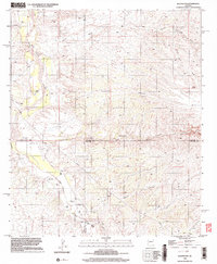
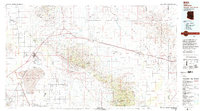 1994 Willcox1994 Print · USGSSoutheast Arizona in the mid-nineties shows a landscape defined by expansive desert basins and rugged sky islands. Genealogists and historians can trace the rail corridor of the Southern Pacific through Willcox, Bowie, and the Kansas Settlement.2 unique versions available
 - 1994 Map of Safford
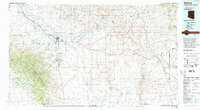 1994 Safford1994 Print · USGSSoutheastern Arizona and the New Mexico borderlands come into focus in the mid-1990s, highlighting the irrigation-fed life of the Gila Valley. Genealogists and researchers can trace local landmarks like Eastern Arizona College, the Southern Pacific RR, and settlements from Artesia to Virden.2 unique versions available
 - 1994 Map of Tucson
 1994 Tucson1994 Print · USGSTucson and the Santa Cruz Valley appear here in the mid-1990s, caught between rapid urban growth and protected wilderness. Researchers can trace the development of Casas Adobes, the operations at Davis Monthan Air Force Base, and the rail lines of the Southern Pacific RR.2 unique versions available
 - 1996 Map of Mount Graham, 2002 Print
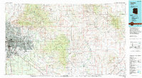
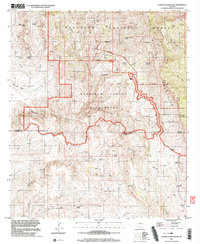
 1996 Mount Graham2002 Print · USGSThe Pinaleño Mountains reach their peaks in the late nineties, documenting the high-country recreation and lookouts of the Coronado National Forest. Researchers can locate the Turkey Flat settlement, the Lookout Tower on Heliograph Peak, and several mountain campsites including Shannon Park.
 - 1996 Map of Webb Peak, 2002 Print
 1996 Webb Peak2002 Print · USGSThe Pinaleno Mountains in the late nineties show a high-country landscape where forest service work centers meet prison history. Trace the Swift Trail to discover sites like the Mt Graham Mill Site, Old Columbine, and the Arizona Bible Sch.
 - 1996 Map of Artesia, 2002 Print
 1996 Artesia2002 Print · USGSThe rural Graham County desert near Artesia comes into focus in the late 1990s, where desert washes meet the foothills. Genealogists can locate the Artesia Cemetery and Artesia Sch, while also tracing the PIPELINE and landmarks like Metate Peak.
 - 1996 Map of Rhodes Peak, 2002 Print
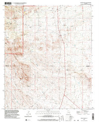
 1996 Rhodes Peak2002 Print · USGSGraham and Pinal Counties in the late 1990s reveal a landscape of high-desert ranching and mining. Trace the remote trails leading to Rhodes Ranch and Mercer Ranch, or locate historical operations like the Magma Mine near Sombrero Butte.
 - 1996 Map of Fort Grant, 2002 Print
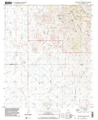
 1996 Fort Grant2002 Print · USGSGraham County ranching and institutional history converge here in the late twentieth century near the Pinaleno Mountains. Genealogists and local historians can trace family properties like Mills Ranch and the site of Fort Grant (State Prison).
 - 1996 Map of Sierra Bonita Ranch, 2002 Print
 1996 Sierra Bonita Ranch2002 Print · USGSIn the mid-nineties, this part of Graham County remained a dedicated ranching landscape centered on the legendary Sierra Bonita Ranch. Researchers can trace old water sources and range infrastructure at Hooker Cienega and the remote High Lonesome Windmill.
 - 1996 Map of Blue Jay Peak, 2002 Print
 1996 Blue Jay Peak2002 Print · USGSGraham County ranching and mining history come alive in the late nineties amidst the Pinaleno Mountains. Trace family-named landmarks and early infrastructure like the Lindsey Grave, President Mine, and the legendary Sierra Bonita Ranch.
 - 1996 Map of Kennedy Peak, 2002 Print
 1996 Kennedy Peak2002 Print · USGSThe Galiuro mountains in the late twentieth century reveal a landscape of rugged ranching outposts and scientific observation. Researchers can trace the Powers Pack Trail to remote locations like Powers Garden, Deer Creek Cabin, and the China Peak Observatory.
 - 1996 Map of Stockton Pass, 2002 Print
 1996 Stockton Pass2002 Print · USGSGraham County ranching and rugged mountain terrain are captured here in the mid-1990s as the high peaks overlook the desert floor. Researchers can locate remote outposts like the C N Ranch and Jernigan Ranch or trace water sources from Kane Spring to Stockton Wash.
 - 1996 Map of Gillespie Mountain, 2002 Print
 1996 Gillespie Mountain2002 Print · USGSArizona's high desert ranching country comes into focus in the mid-nineties, showing the intersection of Coronado National Forest and local landholdings. Trace family-named sites like P Ranch or Van Gausig and the rugged path through Stockton Pass.
 - 1996 Map of Oak Grove Canyon, 2002 Print
 1996 Oak Grove Canyon2002 Print · USGSThe Pinal and Graham County borderlands come alive in the late twentieth century, showing a landscape defined by deep canyons and high desert peaks. Genealogists and historians can trace the mining legacy of the Galiuro Mountains at the Table Mtn Mine, Lime Camp, and Parsons Grove.
 - 1996 Map of Eureka Ranch, 2002 Print
 1996 Eureka Ranch2002 Print · USGSThis late twentieth-century study of the Arizona desert shows the ranching and water infrastructure of Graham County just before the millennium. Researchers can trace remote family burial sites like Whalen Cem or Kennedy Cem and locate landmarks like the River Calderan Ranch.
 - 1996 Map of Harrison Canyon, 2003 Print
 1996 Harrison Canyon2003 Print · USGSGraham County’s high desert landscape comes alive in the 1990s as a complex network of canyons and peaks. Trace local ranching history through water management features like Rincon Dam, the McGee Windmill, and the winding Sunset Loop.
 - 1996 Map of Bassett Peak, 2003 Print
 1996 Bassett Peak2003 Print · USGSArizona's high desert peaks and mining history are recorded here in the mid-1990s, capturing the remote reaches of the Galiuro range. Researchers can locate historical sites like Powers Mine, Hooker Cabin, and the high summit of Bassett Peak.
 - 1996 Map of Greasewood Mountain, 2003 Print
 1996 Greasewood Mountain2003 Print · USGSThe southern Pinaleno Mountains meet the Graham and Cochise county line in the mid-1990s, revealing a landscape defined by desert hydrology and early resource extraction. Researchers can trace historic water sources like Apache Spring and Frog Spring alongside evidence of local mining at Mine Shaft.
 - 1996 Map of Redington, 2003 Print
 1996 Redington2003 Print · USGSThe San Pedro River valley in the late twentieth century reveals a landscape of isolated ranches and desert washes. Trace the local geography of Redington along with the Bingham Ranch, Bayless Ranch, and the Cem near the riverbanks.
 - 1996 Map of Cherry Spring Peak, 2003 Print
 1996 Cherry Spring Peak2003 Print · USGSHigh desert wilderness in Cochise and Graham counties during the late nineties shows a landscape of deep canyons and isolated outposts. Genealogists and historians can locate remote landmarks such as Jackson Cabin, Pride Ranch, and the Bradberry (Site).
 - 1996 Map of Kielberg Canyon, 2003 Print
 1996 Kielberg Canyon2003 Print · USGSThe Galiuro Mountains and the San Pedro River valley define this rugged tri-county border region during the late twentieth century. Researchers can trace remote ranching infrastructure and desert water sources like YLE Ranch, Lower Windmill, and Kielberg Canyon.
 - 1996 Map of Monk Draw, 2003 Print
 1996 Monk Draw2003 Print · USGSThe Graham and Cochise County line comes alive in the mid-1990s, where desert ranching meets the forest edge. Researchers can trace the water-dependent landscape of cattle country through Ten Ranch, Monk Ranch, and the winding Monk Draw.
Showing maps 1-25 of 44
Top cities of Graham County
- Safford historical maps
- Thatcher historical maps
- Pima historical maps
- Swift Trail Junction historical maps
- Bylas historical maps
- Cactus Flat historical maps
See more
Frequently asked questions
- What are the different types of historical maps available for Graham County?
- What is the oldest map of Graham County?
- Where can I purchase historical maps of Graham County for my home or office?
- Where can I download high-res historical maps of Graham County?
- Are there historical topographic maps available for Graham County?
- Is there historical aerial imagery available for Graham County?
- Where are historical maps of Graham County sourced from?