1970s Maps of Graham County, Arizona
Explore 28 historic maps of Graham County from the 1970s. These maps offer a rare glimpse into what life looked like during the 1970s — showing old roads, neighborhoods, homes, and landmarks that have changed or disappeared over time.
Whether you're researching your family's past, planning a metal detecting trip, or studying how Graham County's landscape evolved across the 1970s, these high-resolution maps are a powerful tool for exploring the history of this region.
- Focus on a specific era: All maps on this page are from the 1970s, giving you a focused view of this time period.
- See what’s changed: Compare century-old streets, trails, and buildings to today's modern landscape using overlays and satellite layers.
- Research with precision: Use these maps for genealogy, historical research, land use analysis, or educational projects.
- View, download, or print: Maps are fully viewable online in high resolution, and can be downloaded or printed for your own records.
Start exploring Graham County's history through authentic maps from the 1970s. This is your window into the past.
Graham County, AZ maps
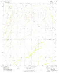
(28)- 1972 Map of Klondyke, 1975 Print
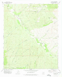 1972 Klondyke1975 Print · USGSSettlement and mining activity characterize this Graham County canyon land in the early seventies. Genealogists and local historians can locate the Klondyke Cem and trace the proximity of the Dog Water Mine and Quinn Mine to Klondyke.4 unique versions available
 - 1972 Map of Mt. Graham, 1975 Print
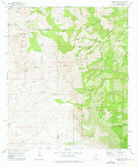
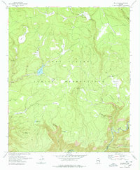
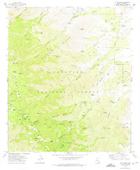 1972 Mt. Graham1975 Print · USGSGraham County, Arizona, is captured in the early 1970s as a high-altitude sanctuary within the Coronado National Forest. Researchers can trace early mountain developments like Turkey Flat, the Angle Orchard, and the remote Heliograph Peak lookout.3 unique versions available
 - 1972 Map of Kennedy Peak, 1975 Print
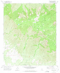
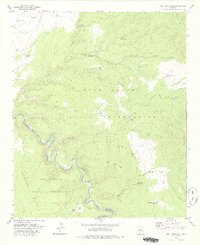
 1972 Kennedy Peak1975 Print · USGSGraham County’s high backcountry in the early 1970s is shown here as a landscape of isolated peaks and cattle-ranching outposts. Researchers can trace remote mountain sites such as the China Peak Observatory, Deer Creek Ranch, and the hidden Powers Garden.2 unique versions available
 - 1972 Map of Tripp Canyon, 1975 Print
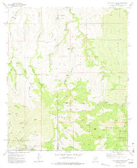
 1972 Tripp Canyon1975 Print · USGSArizona's high desert reveals its ranching and resource history in the 1970s through a detailed network of springs and stock tanks. Trace old routes like the Bellows Trail past the Pinaleno Mountains, or locate the isolated Grave and Lindsey site.
 - 1972 Map of Webb Peak, 1975 Print
 1972 Webb Peak1975 Print · USGSThe high peaks of the Pinaleno Mountains are captured here in the early 1970s as the area balanced forest management with recreation. Researchers can trace the layout of Fort Grant (State Industrial School) or locate the Mt Graham Mill Site and Arizona Bible Sch.4 unique versions available
 - 1972 Map of Oak Grove Canyon, 1975 Print
 1972 Oak Grove Canyon1975 Print · USGSArizona's remote Galiuro Mountains are shown in the early 1970s, during a period when mining and ranching still shaped the high desert landscape. Genealogists and historians can trace family-named sites and claims like Parsons Grove, Fourmile Ranch, and the Bluebird Mine.2 unique versions available
 - 1972 Map of Harrison Canyon, 1975 Print
 1972 Harrison Canyon1975 Print · USGSGraham County ranching and rugged canyon terrain are captured here in the early 1970s. Researchers can locate remote water infrastructure and landmarks like McGee Windmill, Renee Spring, and the Rincon Dam set against the Galiuro Mountains.2 unique versions available
 - 1972 Map of Rhodes Peak, 1975 Print
 1972 Rhodes Peak1975 Print · USGSThe Galiuro Mountains take center stage in the 1970s, showing a rugged landscape defined by deep canyons and isolated ranching outposts. Researchers can trace historical mineral sites like Magma Mine or locate early water sources such as Mailbox Well and Rhodes Ranch.2 unique versions available
 - 1972 Map of Jackson Mtn., 1975 Print
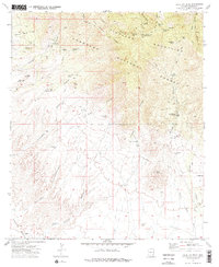
 1972 Jackson Mtn.1975 Print · USGSGraham County ranching and reservation lands are captured in the early 1970s before modern development altered this high-desert terrain. Researchers can locate remote homesteads like Hinton Ranch and natural landmarks such as Carpenters Cave and Cobre Grande Peak.2 unique versions available
 - 1972 Map of Fort Grant, 1975 Print
 1972 Fort Grant1975 Print · USGSGraham County ranching and military history converge in the 1970s at the base of the mountains. Researchers can trace the Fort Grant Military Reservation Bdy, the Old Military Road, and legacy ranch sites like Mills Ranch.
 - 1972 Map of Blue Jay Peak, 1975 Print
 1972 Blue Jay Peak1975 Print · USGSGraham County cattle ranching and high-country mining are preserved here in the early seventies. Genealogists and historians can trace the KH Ranch, locate the Lindsey Grave, and find the remote President Mine among the peaks of the Pinaleno Mountains.2 unique versions available
 - 1972 Map of Sierra Bonita Ranch, 1975 Print
 1972 Sierra Bonita Ranch1975 Print · USGSGraham County ranching and desert terrain are captured in the early seventies, centered on the legacy of the Sierra Bonita Ranch. Researchers can trace old cattle-working infrastructure like Red Corral, water sources at Hooker Cienega, and the High Lonesome Windmill.
 - 1972 Map of Telegraph Wash, 1975 Print
 1972 Telegraph Wash1975 Print · USGSGraham County's high desert and mountain slopes are captured here in the early 1970s, showing the intersection of ranching life and tribal lands. Researchers can trace remote desert outposts like the Y L Ranch and vital water points such as Mesquite Well and VJ Tank.
 - 1972 Map of Eureka Ranch, 1975 Print
 1972 Eureka Ranch1975 Print · USGSGraham County ranching and canyon life are documented here in the early 1970s. Genealogists and historians can locate remote family landmarks like Whalen Cem. and Johns Cem. or trace water sources from Paddy Lynch Windmill to Walnut Spring.
 - 1972 Map of Cobre Grande Mtn, 1975 Print
 1972 Cobre Grande Mtn1975 Print · USGSThe high peaks of the Santa Teresa Mountains were a hub of remote mining activity in the early 1970s. Researchers can trace historic prospecting sites like the Grand Reef Mine and Tenstrike Mine, or locate old camps such as Landsman Camp.
 - 1972 Map of Bassett Peak, 1975 Print
 1972 Bassett Peak1975 Print · USGSGraham County’s high backcountry in the early seventies remains a landscape of isolated mines and spring-fed canyons. Researchers can trace remote mining history at Powers Mine and Long Tom Mine, or locate old ranching landmarks like Hooker Cabin and Browning Dam.2 unique versions available
 - 1972 Map of Buford Hill, 1975 Print
 1972 Buford Hill1975 Print · USGSGraham County's high desert and mountain terrain are captured here in the early seventies, detailing the remote rangeland of the Coronado National Forest. Researchers can trace historic water sources and primitive routes like Kennedy Falls Trail, or locate the isolated Cem and Prospects near Aravaipa Creek.
 - 1972 Map of Stockton Pass, 1975 Print
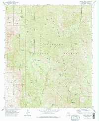
 1972 Stockton Pass1975 Print · USGSThe Pinaleno Mountains and Coronado National Forest are captured here in the early seventies, detailing a landscape of high summits and remote ranching. Genealogists and hikers can trace old routes to the C N Ranch, Jernigan Ranch, and Stockton Pass.
 - 1972 Map of Booger Canyon, 1975 Print
 1972 Booger Canyon1975 Print · USGSThe rugged canyonlands of Graham and Pinal counties appear in the early 1970s, as the San Carlos Indian Reservation meets the Aravaipa Canyon. Genealogists and researchers can trace local landmarks like Salazar Cem, ancient Cliff Dwelling sites, and the Ash Creek Dam.2 unique versions available
 - 1972 Map of Kielberg Canyon, 1975 Print
 1972 Kielberg Canyon1975 Print · USGSSoutheastern Arizona rangeland and canyon country are preserved in this early 1970s survey of the Galiuro Mountains. Researchers can trace old stock-raising and mining sites like YLE Ranch, the 16 to 1 Mine, and Peters Well.2 unique versions available
 - 1974 Map of Martin Well, 1977 Print
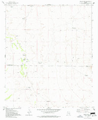 1974 Martin Well1977 Print · USGSCrossing the Cochise and Graham County line in the mid-seventies, this survey maps the essential water infrastructure of the San Simon Valley. Researchers can trace remote desert outposts like Chaney Place, Rabbit Farm, and Martin Well.
 - 1974 Map of Ryan Draw, 1977 Print
 1974 Ryan Draw1977 Print · USGSThe Graham and Cochise County line meets in this high-desert landscape during the mid-seventies, showing a remote world of ranching and water management. Researchers can trace the rugged Jeep Trails past Foote Ranch, Antelope Well, and numerous hillside Mine prospects.
 - 1976 Map of Elwood Canyon, 1977 Print
 1976 Elwood Canyon1977 Print · USGSArizona's tribal lands meet along the Black River in the mid-1970s, showcasing a landscape defined by deep canyons and high plateaus. Researchers can trace remote water improvements and historical pathways like the Elwood Windmill, Bloody Basin, and numerous Pack Trails.
 - 1978 Map of Maverick
 1978 Maverick1978 Print · USGSThe high cienegas and reservation lands of eastern Arizona are documented here during the late seventies. Researchers can trace the cattle and timber history of the region through landmarks like Odart Ranch, Maverick, and the waters of Tonto Lake.
 - 1978 Map of West Poker Mtn.
 1978 West Poker Mtn.1978 Print · USGSThe high desert borderland between the San Carlos and Fort Apache Indian Reservations is captured here in the late 1970s. Trace the winding Black River as it cuts through the Natanes Plateau past remote features like Mormon Canyon and Carlos Moody Tank.
Showing maps 1-25 of 28
Top cities of Graham County
- Safford historical maps
- Thatcher historical maps
- Pima historical maps
- Swift Trail Junction historical maps
- Bylas historical maps
- Cactus Flat historical maps
See more
Frequently asked questions
- What are the different types of historical maps available for Graham County?
- What is the oldest map of Graham County?
- Where can I purchase historical maps of Graham County for my home or office?
- Where can I download high-res historical maps of Graham County?
- Are there historical topographic maps available for Graham County?
- Is there historical aerial imagery available for Graham County?
- Where are historical maps of Graham County sourced from?