1900s (20th Century) Maps of Graham County, Arizona
Explore 209 historic maps of Graham County from the 1900s (20th Century). These maps offer a rare glimpse into what life looked like during the 1900s — showing old roads, neighborhoods, homes, and landmarks that have changed or disappeared over time.
Whether you're researching your family's past, planning a metal detecting trip, or studying how Graham County's landscape evolved across the 1900s, these high-resolution maps are a powerful tool for exploring the history of this region.
- Focus on a specific era: All maps on this page are from the 1900s, giving you a focused view of this time period.
- See what’s changed: Compare century-old streets, trails, and buildings to today's modern landscape using overlays and satellite layers.
- Research with precision: Use these maps for genealogy, historical research, land use analysis, or educational projects.
- View, download, or print: Maps are fully viewable online in high resolution, and can be downloaded or printed for your own records.
Start exploring Graham County's history through authentic maps from the 1900s. This is your window into the past.
Graham County, AZ maps
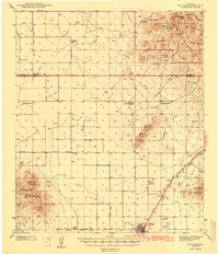
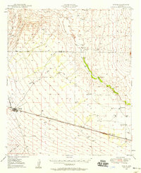
(209)- 1902 Map of Clifton
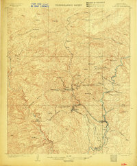 1902 Clifton1902 Print · USGSMining and rail history converge in this 1902 portrait of the Arizona Territory's copper belt. Researchers can trace the industrial layout of Morenci and Clifton, identifying the routes of the Coronado RR and the specialized King Incline.3 unique versions available
 - 1913 Map of Morenci, 1954 Print
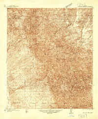
 1913 Morenci1954 Print · USGSArizona's copper country and high timberlands meet in this pre-war survey of the Morenci district and Apache National Forest. Researchers can trace the early industrial footprint of Morenci and Clifton or find family landmarks like Miller Cabin and Cooks Ranch.2 unique versions available
 - 1915 Map of Morenci
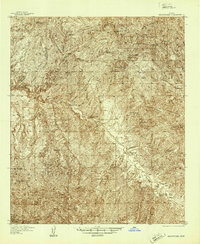
 1915 Morenci1915 Print · USGSGreenlee County during the early 1900s shows a landscape defined by industrial copper mining and isolated high-desert ranching. Genealogists and historians can trace family locations from the Eagle Creek School to historic homesteads like Dudley Ranch and the settlement of Oroville.3 unique versions available
 - 1917 Map of San Simon
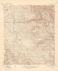
 1917 San Simon1917 Print · USGSArizona and New Mexico ranching and rail history meet here during the years following the border surveys. Genealogists and historians can locate remote family sites like Posey Ranch, the historical Old Fort Bowie, and early copper or granite works at Willie Rose Mine.3 unique versions available
 - 1922 Map of Willcox
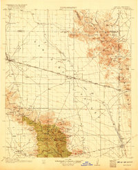
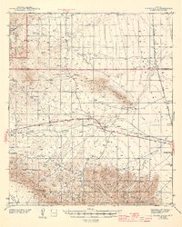
 1922 Willcox1922 Print · USGSCochise County’s high-desert ranching and mining heartland is captured in the early 1920s as a thriving railroad hub. Genealogists can trace family holdings and rail stops across the basin, from Willcox and Servoss to the Mascot Mine and Circle I Ranch.
 - 1922 Map of Nutrioso
 1922 Nutrioso1922 Print · USGSHigh-altitude ranching and forest service outposts define the Arizona-New Mexico border in the early twenties. Researchers can trace remote family landmarks like Reservation Ranch and Colter's Res. or locate early settlements at Nutrioso and Alpine.
 - 1926 Map of Orange Butte
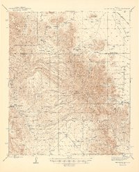
 1926 Orange Butte1926 Print · USGSCochise County's desert frontier comes into sharp focus during the mid-twenties, tracing the borderlands from the Peloncillo Mountains to the Animas Valley. Researchers can locate dozens of family-named landmarks like Lyall Ranch and Chamberlin Ranch, alongside working claims at Volcano Mine.
 - 1928 Map of Bowie
 1928 Bowie1928 Print · USGSCochise County ranching and rail life are recorded in detail during the late twenties, centered on the hub of Bowie. Genealogists and historians can trace numerous family operations like Henderson Ranch and Old Lyday Ranch, or locate the Artesia School along the Southern Pacific line.
 - 1938 Map of Galiuro Mts
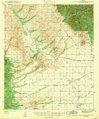
 1938 Galiuro Mts1938 Print · USGSThe high desert of Graham and Pinal Counties comes alive in this pre-war survey of the Galiuro Mountains. Local history researchers can trace old ranching boundaries and mining claims like Sixteen To One Mine, Y L Ranch, and the Gerónimo Camp outpost.5 unique versions available
 - 1938 Map of Klondyke
 1938 Klondyke1938 Print · USGSThe mining and ranching outposts of the Aravaipa Valley are captured here in the late 1930s. Genealogists and historians can trace old homesteads and extraction sites like Landsman Camp, the Grand Reef Mine, and the local Aravaipa Sch near the creek.3 unique versions available
 - 1940 Map of Sierra Bonita Ranch, 1960 Print
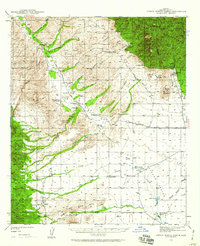 1940 Sierra Bonita Ranch1960 Print · USGSGraham County ranching and rugged canyon lands are captured here just before the 1940s, showing a landscape of remote outposts and high-desert water sources. Researchers can trace the heritage of the Sierra Bonita Ranch, locate the Sunset School, or find vanished sites like the Shotgun Smith Ranch (Abandoned).2 unique versions available
 - 1942 Map of Sierra Bonita Ranch
 1942 Sierra Bonita Ranch1942 Print · USGSGraham County cattle country comes to life in the early 1940s, showing a vast ranching landscape defined by remote outposts and scarce water. Trace the locations of historic headquarters like Sierra Bonita Ranch and Eureka Ranch, or find the lonely Sunset School and Whalum Cem.
 - 1942 Map of Mt. Graham, 1945 Print
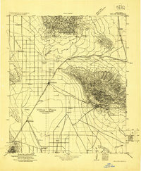
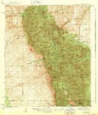
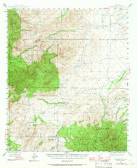
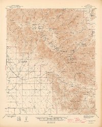 1942 Mt. Graham1945 Print · USGSThe Pinaleno Mountains rise sharply from the desert floor in the early 1940s, showing a landscape defined by forest service outposts and cattle ranches. Researchers can trace historic landmarks like Fort Grant (PO), the Columbine Ranger Station, and the winding Swift Trail.3 unique versions available
 - 1943 Map of Willcox
 1943 Willcox1943 Print · USGSIn the early 1940s, the cattle ranches and rail lines of southeastern Arizona defined the high desert landscape. Genealogists and researchers can locate family sites like the Brookerson Ranch, follow the Southern Pacific tracks through Raso, or find the Stewart Sch.3 unique versions available
 - 1943 Map of Galiuro Mts
 1943 Galiuro Mts1943 Print · USGSThe high desert of the Galiuro Mountains comes into focus in the late 1930s, showing a rugged landscape defined by cattle ranching and mining. You can trace the locations of family holdings like Mercer Ranch and Daley Ranch or search for remote mine sites like the Bunker Hill Mine.2 unique versions available
 - 1943 Map of Klondyke
 1943 Klondyke1943 Print · USGSGraham County’s high desert mining and forest landscape is captured here during the 1940s. Genealogists and researchers can trace the vicinity of the Klondyke settlement, the Aravaipa Sch, and numerous local workings like the Grand Reef Mine.2 unique versions available
 - 1943 Map of Sierra Bonita Ranch
 1943 Sierra Bonita Ranch1943 Print · USGSGraham County ranching and mountain mining are frozen in time during the early 1940s. Genealogists and historians can trace the legacy of the Sierra Bonita Ranch, locate the remote Sunset School, and explore the canyon lands near the President Mine.2 unique versions available
 - 1943 Map of Winchester Mts. , 1945 Print
 1943 Winchester Mts.1945 Print · USGSSoutheastern Arizona's high desert cattle country is captured here during the early 1940s. Genealogists and historians can trace numerous remote homesteads and water sources, including Muleshoe Ranch, Antelope Ranch, and Hooker Hot Springs.2 unique versions available
 - 1944 Map of Jackson Mtn.
 1944 Jackson Mtn.1944 Print · USGSIn the high desert of Graham County during the mid-1940s, ranching life and mining prospects define the terrain. Genealogists and historians can trace the footprints of early settlers at the Hinton Ranch, Ferguson Ranch, and Moody Ranch.3 unique versions available
 - 1944 Map of Fisher Hills
 1944 Fisher Hills1944 Print · USGSSoutheast Arizona in the early 1940s is defined here by the Southern Pacific rail line and the sprawling cattle ranches of Cochise County. Genealogists and historians can trace old homesteads and stations like Luzena, the Flying W Ranch, and the inactive CCC Camp near the mountains.3 unique versions available
 - 1945 Map of Mt. Graham
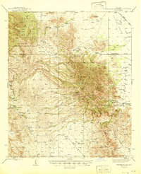
 1945 Mt. Graham1945 Print · USGSGraham County ranching and forestry are captured here in the mid-1940s, from the valley floor to the high peaks. Genealogists can locate family landmarks like the Mills Ranch, Cluff Dairy, and the State Industrial School.
 - 1945 Map of Redington
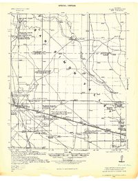
 1945 Redington1945 Print · USGSThe San Pedro River valley in the 1940s was a landscape of remote cattle ranches and mining claims. Genealogists and historians can trace family properties like Bingham Ranch, locate the Pool Sch, and find the historic Jackson Mine.2 unique versions available
 - 1945 Map of Winchester Mts.
 1945 Winchester Mts.1945 Print · USGSCochise and Graham Counties in the 1940s were a landscape of remote cattle operations and high-desert peaks. Researchers can trace the heritage of family-named outposts like the Muleshoe Ranch and Lee Ranch, or locate water sources like Hookers Hot Springs.
 - 1946 Map of Jackson Mtn.
 1946 Jackson Mtn.1946 Print · USGSGraham County ranching and rugged national forest lands are captured here during the mid-forties. Genealogists and historians can locate legacy homesteads like Hinton Ranch and Ferguson Ranch or trace the route of the old Goodwin Trail.
 - 1949 Map of Bowie, 1958 Print
 1949 Bowie1958 Print · USGSThe Southern Pacific railroad and the cattle ranches of Cochise County define this desert landscape in the late 1940s. Genealogists and historians can trace family-named sites like Garrett Ranch and the station at Bowie.2 unique versions available
Showing maps 1-25 of 209
Top cities of Graham County
- Safford historical maps
- Thatcher historical maps
- Pima historical maps
- Swift Trail Junction historical maps
- Bylas historical maps
- Cactus Flat historical maps
See more
Frequently asked questions
- What are the different types of historical maps available for Graham County?
- What is the oldest map of Graham County?
- Where can I purchase historical maps of Graham County for my home or office?
- Where can I download high-res historical maps of Graham County?
- Are there historical topographic maps available for Graham County?
- Is there historical aerial imagery available for Graham County?
- Where are historical maps of Graham County sourced from?