1970s Maps of Kings County, California
Explore 4 historic maps of Kings County from the 1970s. These maps offer a rare glimpse into what life looked like during the 1970s — showing old roads, neighborhoods, homes, and landmarks that have changed or disappeared over time.
Whether you're researching your family's past, planning a metal detecting trip, or studying how Kings County's landscape evolved across the 1970s, these high-resolution maps are a powerful tool for exploring the history of this region.
- Focus on a specific era: All maps on this page are from the 1970s, giving you a focused view of this time period.
- See what’s changed: Compare century-old streets, trails, and buildings to today's modern landscape using overlays and satellite layers.
- Research with precision: Use these maps for genealogy, historical research, land use analysis, or educational projects.
- View, download, or print: Maps are fully viewable online in high resolution, and can be downloaded or printed for your own records.
Start exploring Kings County's history through authentic maps from the 1970s. This is your window into the past.
Kings County, CA maps
(4)- 1970 Map of Burrel
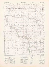 1970 Burrel1970 Print · USGSAgricultural and industrial growth converge in Fresno County at the start of the seventies. Genealogists and historians can trace the irrigation networks of Murphy Slough and locate sites like Bender Union Sch or the Oil Field near Lanare.
 - 1974 Map of Monterey, 1977 Print
 1974 Monterey1977 Print · USGSThe Central Coast and San Joaquin Valley meet in this mid-seventies survey of the Monterey region. Genealogists and historians can locate Spanish-era sites like the San Antonio de Padua Mission, early industrial markers such as the New Idria Mine, and coastal landmarks like the Point Sur Lighthouse.
 - 1976 Map of Hanford, 1980 Print
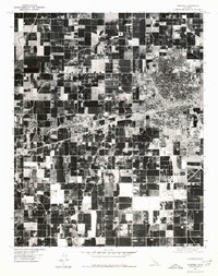 1976 Hanford1980 Print · USGSCentral Valley agriculture and urban expansion define this Kings County landscape in the mid-seventies. Researchers can trace the development of the city of Hanford or the smaller clusters at Armona and Grangeville.
 - 1976 Map of Lemoore, 1980 Print
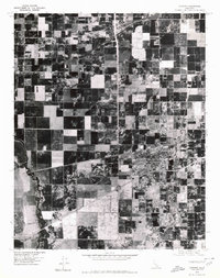 1976 Lemoore1980 Print · USGSThe agricultural heart of Kings County is captured in this mid-seventies aerial survey, showing the town of Lemoore amid a sea of productive fields. Trace the winding paths of the North Fork Kings River and Clarks Fork as they cut through the rural landscape.
End of results
Showing maps 1-4 of 4
Top cities of Kings County
- Hanford historical maps
- Corcoran historical maps
- Lemoore historical maps
- Avenal historical maps
- Armona historical maps
- Home Garden historical maps
See more
Frequently asked questions
- What are the different types of historical maps available for Kings County?
- What is the oldest map of Kings County?
- Where can I purchase historical maps of Kings County for my home or office?
- Where can I download high-res historical maps of Kings County?
- Are there historical topographic maps available for Kings County?
- Is there historical aerial imagery available for Kings County?
- Where are historical maps of Kings County sourced from?