2020s Maps of Kings County, California
Explore 35 historic maps of Kings County from the 2020s. These maps offer a rare glimpse into what life looked like during the 2020s — showing old roads, neighborhoods, homes, and landmarks that have changed or disappeared over time.
Whether you're researching your family's past, planning a metal detecting trip, or studying how Kings County's landscape evolved across the 2020s, these high-resolution maps are a powerful tool for exploring the history of this region.
- Focus on a specific era: All maps on this page are from the 2020s, giving you a focused view of this time period.
- See what’s changed: Compare century-old streets, trails, and buildings to today's modern landscape using overlays and satellite layers.
- Research with precision: Use these maps for genealogy, historical research, land use analysis, or educational projects.
- View, download, or print: Maps are fully viewable online in high resolution, and can be downloaded or printed for your own records.
Start exploring Kings County's history through authentic maps from the 2020s. This is your window into the past.
Kings County, CA maps
(35)- 2021 Map of El Rico Ranch, 2021 Print
 2021 El Rico Ranch2021 Print · USGSThe irrigated ranch lands of the San Joaquin Valley are captured here in the early twenty-first century. Researchers can trace the sophisticated water networks of the Tulare Lake Canal, Tule River, and Gates-Jones Canal.
 - 2021 Map of Avenal, 2021 Print
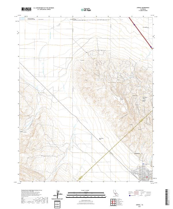 2021 Avenal2021 Print · USGSKings County's western edge comes into focus in this recent survey of the petroleum and agricultural lands surrounding the Kettleman Hills. Genealogists and historians can trace the streets of Avenal and navigate the natural drainages of Zapato Chino Canyon and Arroyo Ciervo.
 - 2021 Map of Riverdale, 2021 Print
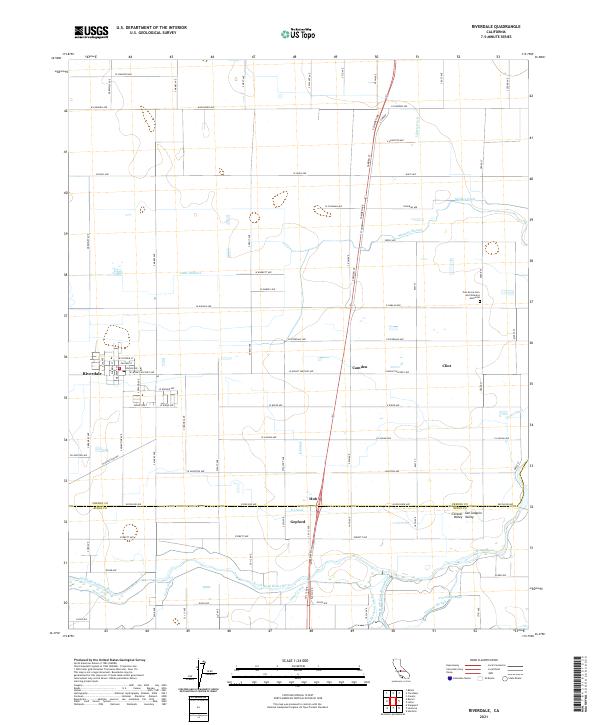 2021 Riverdale2021 Print · USGSThe San Joaquin Valley is captured here during the early twenty-first century, showing a landscape of precise irrigation and rural settlement. Researchers can trace the complex water networks of the North Fork Kings River and find local landmarks like Gepford and the Oak Grove Cem and Veterans Memorial.
 - 2021 Map of Burrel, 2021 Print
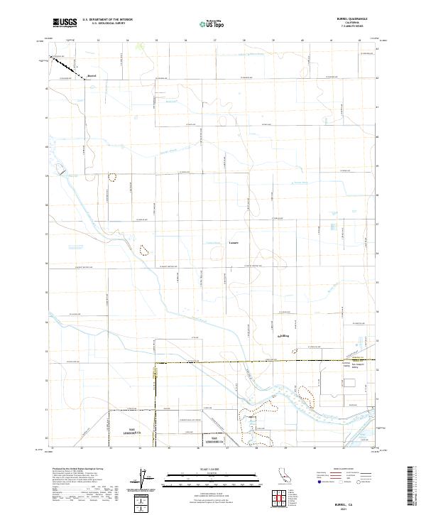 2021 Burrel2021 Print · USGSThe agricultural heart of the San Joaquin Valley is mapped here during a period of modern irrigation and military presence. Researchers can trace the water-rights history of the region through landmarks like Fresno Slough, the Liberty Millrace Canal, and the northern edge of the Lemoore Naval Air Station.
 - 2021 Map of Corcoran, 2021 Print
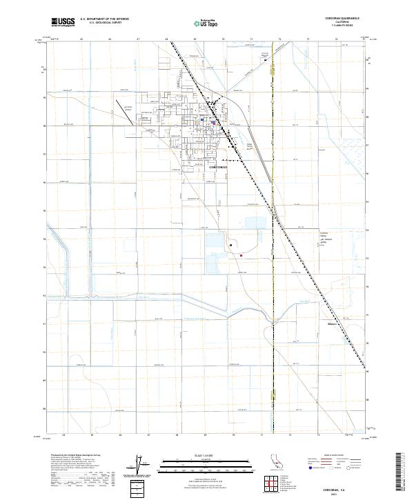 2021 Corcoran2021 Print · USGSCorcoran and the surrounding San Joaquin Valley are captured in this recent survey of California's agricultural heartland. Researchers can trace irrigation networks like the Helm-Lewis Ditch and Tule River or locate family sites at Corcoran Memorial Park and Blanco.
 - 2021 Map of Waukena, 2021 Print
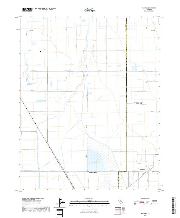 2021 Waukena2021 Print · USGSThe Tulare County agricultural landscape at the edge of the Tulare Basin is captured here in the early 2020s. Researchers can trace the sophisticated irrigation network of the Highline Canal and Bean Ditch surrounding the settlement of Waukena.
 - 2021 Map of Vanguard, 2021 Print
 2021 Vanguard2021 Print · USGSThe Central Valley's military and agricultural landscape is revealed in this modern survey, showing the expansive Lemoore Naval Air Station. Researchers can trace irrigation networks along the North Fork Kings River and the small settlement of Vanguard.
 - 2021 Map of Lemoore, 2021 Print
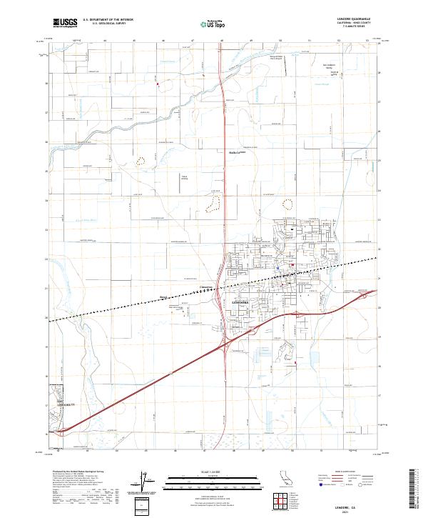 2021 Lemoore2021 Print · USGSThe agricultural heart of the San Joaquin Valley is revealed in this contemporary survey of Kings County. Researchers can trace the layout of Lemoore and its outlying districts like Rossi and Cimarron, while locating family-history sites such as the Lemoore Cem.
 - 2021 Map of Stratford SE, 2021 Print
 2021 Stratford SE2021 Print · USGSThe agricultural heart of the San Joaquin Valley is laid out in this modern survey, highlighting the intersection of the Kings River and Tule River. Researchers can trace the edges of the Tulare Lake Bed and the extensive irrigation network of the Wilbur Ditch.
 - 2021 Map of Guernsey, 2021 Print
 2021 Guernsey2021 Print · USGSAgricultural lands in the San Joaquin Valley are captured here in the 2020s, showing a complex network of irrigation and drainage. Researchers can trace historic water routes like Mussel Slough and Lone Oak Canal near the settlement of Guernsey.
 - 2021 Map of Laton, 2021 Print
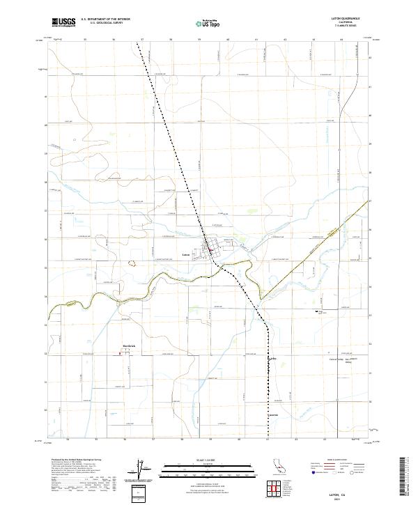 2021 Laton2021 Print · USGSThe agricultural heart of the San Joaquin Valley is shown here in the 2020s, centered on the Kings River and the community of Laton. Researchers can trace the complex irrigation network through Riverside Ditch and Peoples Ditch, or locate the Kings River Cem and the settlement of Hardwick.
 - 2021 Map of Westhaven, 2021 Print
 2021 Westhaven2021 Print · USGSKings County farming and irrigation are captured here in the early twenty-first century as the landscape remains defined by vast agricultural grids. Researchers can trace local infrastructure from the Stone Land Co Airport to the vital Empire Westside Ditch near Westhaven.
 - 2021 Map of Remnoy, 2021 Print
 2021 Remnoy2021 Print · USGSThe agricultural heart of the San Joaquin Valley comes into focus in this modern survey of the eastern outskirts of Hanford. Researchers can trace the vital irrigation networks of the Lakeland Canal and Highline Canal alongside smaller hubs like Remnoy and Hamblin.
 - 2021 Map of Huron, 2021 Print
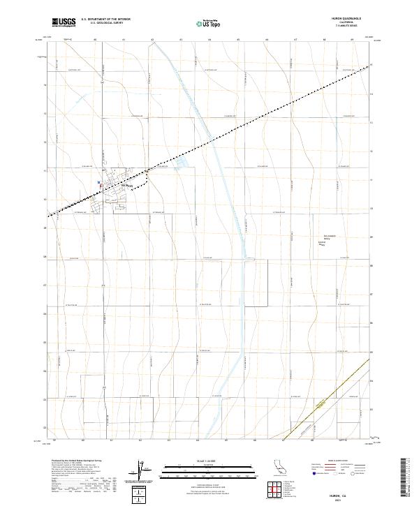 2021 Huron2021 Print · USGSHuron and the surrounding San Joaquin Valley are captured here in a moment of modern agricultural intensity. Researchers can trace the path of the Governor Edmund G Brown California Aqueduct and locate the border between Fresno Co and Kings Co.
 - 2021 Map of Stratford, 2021 Print
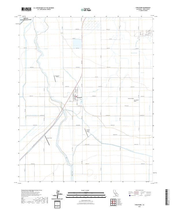 2021 Stratford2021 Print · USGSThe agricultural heart of the San Joaquin Valley comes into focus here during the early 2020s. Researchers can trace the sophisticated irrigation network of the Empire Canal and Tulare Lake Canal surrounding Stratford and the Kings River.
 - 2021 Map of La Cima, 2021 Print
 2021 La Cima2021 Print · USGSKings County at the turn of the 2020s shows the stark meeting of industrial water infrastructure and the rugged Kettleman Hills. Researchers can trace the path of the California Aqueduct as it passes north of Avenal and Hydril Hill.
 - 2021 Map of The Dark Hole, 2021 Print
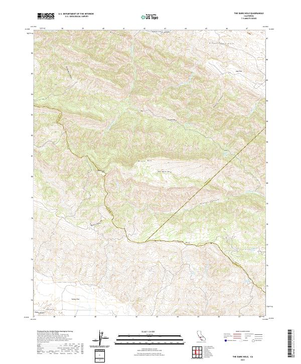 2021 The Dark Hole2021 Print · USGSThe Diablo Range highlands at the junction of three counties are detailed here in the early 2020s. Researchers can trace land use patterns and water sources across Turkey Flat, The Dark Hole, and family-named landmarks like Reese Canyon.
 - 2021 Map of Hacienda Ranch, 2021 Print
 2021 Hacienda Ranch2021 Print · USGSThe San Joaquin Valley at the intersection of Kings, Tulare, and Kern Counties reveals a landscape of industrial agriculture in the early twenty-first century. Researchers can trace the engineering of the valley floor through the Homeland Canal, Sand Ridge, and the drainage patterns of the Goose Lake Canal.
 - 2021 Map of Avenal Gap, 2021 Print
 2021 Avenal Gap2021 Print · USGSThe border of Kings and Kern Counties comes into focus in this recent survey of the Central Valley's rugged western margin. Genealogists and researchers can trace the modern California Aqueduct as it passes through Avenal Gap between Kettleman Hills and Pyramid Hills.
 - 2021 Map of Hacienda Ranch NW, 2021 Print
 2021 Hacienda Ranch NW2021 Print · USGSThe agricultural landscape of the San Joaquin Valley is captured here in the early twenty-first century. Genealogists and researchers can trace land parcels and irrigation routes along the Gates Jones Canal and Pelican Island.
 - 2021 Map of Dudley Ridge, 2021 Print
 2021 Dudley Ridge2021 Print · USGSKings County agricultural lands are captured here during the early 2020s, revealing a landscape shaped by water and work. Researchers can trace the path of the Blakeley Canal or the elevation changes along the distinct Dudley Ridge.
 - 2021 Map of West Camp, 2021 Print
 2021 West Camp2021 Print · USGSAgricultural sections and massive water infrastructure define this portion of the San Joaquin Valley in the early 2020s. Researchers can trace the path of the Governor Edmund G Brown California Aqueduct and the elevation of Sand Ridge along the county line.
 - 2021 Map of Hacienda Ranch NE, 2021 Print
 2021 Hacienda Ranch NE2021 Print · USGSKings and Tulare counties in the early twenty-first century are defined by a vast agricultural grid and intricate irrigation networks. Researchers can trace the path of water through the Main Canal, the Lamberson Ditch, and the diagonally-cut Homeland Canal.
 - 2021 Map of Kettleman Plain, 2021 Print
 2021 Kettleman Plain2021 Print · USGSThe oil-rich ridges of Kings County come into focus during the early twenty-first century as industrial and natural landscapes intersect. Researchers can trace the unique topography of Kettleman Hills and locate specific landmarks like Reef Station and Drillers Ridge.
 - 2021 Map of Lone Tree Well, 2021 Print
 2021 Lone Tree Well2021 Print · USGSThe agricultural heart of the San Joaquin Valley is revealed in this contemporary survey of the Kings and Kern County border. Researchers can trace the complex water management systems of the Kern River Channel, Hacienda Spillway, and the rise of Sand Ridge.
Showing maps 1-25 of 35
Top cities of Kings County
- Hanford historical maps
- Corcoran historical maps
- Lemoore historical maps
- Avenal historical maps
- Armona historical maps
- Home Garden historical maps
See more
Frequently asked questions
- What are the different types of historical maps available for Kings County?
- What is the oldest map of Kings County?
- Where can I purchase historical maps of Kings County for my home or office?
- Where can I download high-res historical maps of Kings County?
- Are there historical topographic maps available for Kings County?
- Is there historical aerial imagery available for Kings County?
- Where are historical maps of Kings County sourced from?