1940s Maps of Kings County, California
Explore 18 historic maps of Kings County from the 1940s. These maps offer a rare glimpse into what life looked like during the 1940s — showing old roads, neighborhoods, homes, and landmarks that have changed or disappeared over time.
Whether you're researching your family's past, planning a metal detecting trip, or studying how Kings County's landscape evolved across the 1940s, these high-resolution maps are a powerful tool for exploring the history of this region.
- Focus on a specific era: All maps on this page are from the 1940s, giving you a focused view of this time period.
- See what’s changed: Compare century-old streets, trails, and buildings to today's modern landscape using overlays and satellite layers.
- Research with precision: Use these maps for genealogy, historical research, land use analysis, or educational projects.
- View, download, or print: Maps are fully viewable online in high resolution, and can be downloaded or printed for your own records.
Start exploring Kings County's history through authentic maps from the 1940s. This is your window into the past.
Kings County, CA maps
(18)- 1940 Map of Stratford, 1954 Print
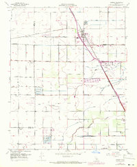
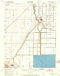 1940 Stratford1954 Print · USGSThe reclaimed basin of the San Joaquin Valley comes into focus just before the mid-century, showing a landscape defined by industrial-scale irrigation and oil. Genealogists can locate family raches and rural schools like Ramona Sch, while tracing the early footprints of Stratford and Kettleman City.
 - 1942 Map of Polvadero Gap
 1942 Polvadero Gap1942 Print · USGSCentral California ranching and early rail corridors appear in high detail during the early war years. Genealogists and local historians can locate early family holdings like Kreyenhagen Ranch, the town of Huron, and the Southern Pacific line.2 unique versions available
 - 1942 Map of Corcoran
 1942 Corcoran1942 Print · USGSThe Central Valley agricultural landscape of Kings and Tulare counties is shown here during the early years of the war. Genealogists and historians can trace rail-side commerce and rural schooling at Waukena, Corcoran, and several family outposts like the El Rico Ranch.
 - 1942 Map of Liberty Farms
 1942 Liberty Farms1942 Print · USGSThe reclaimed basin of Kings County is shown at the height of its early industrial ranching era, just after the turn of the decade. Genealogists and historians can trace the vast holdings of Harvester Ranch, Hacienda Ranch, and the Westlake Gun Club.2 unique versions available
 - 1942 Map of Tent Hills, 1960 Print
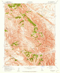 1942 Tent Hills1960 Print · USGSIn the early 1940s, this pocket of the California Coast Ranges was a rugged intersection of ranch land and high ridges. Genealogists and historians can trace old homestead boundaries and early routes through Cottonwood Pass, Iron Spring Ranch, and Fahey Ranch.2 unique versions available
 - 1943 Map of Tent Hills
 1943 Tent Hills1943 Print · USGSThe rugged junction of four California counties during the early 1940s is detailed here through the peaks of the Diablo Range. Genealogists and historians can trace family-named outposts like Acebedo Ranch and landmarks at Polonio Pass.
 - 1943 Map of Stratford
 1943 Stratford1943 Print · USGSMid-century Kings County reveals a landscape of massive water engineering projects and valley farming as the Second World War began. Researchers can trace irrigation networks from Tulare Lake, find early school sites like Ramona Sch, and locate the Pacific Southern rail stops at Westhaven Station.
 - 1943 Map of La Rambla
 1943 La Rambla1943 Print · USGSThe southern Central Valley meets the oil-rich heights of the Kettleman Hills in the early 1940s. Genealogists and historians can trace the early industrial footprint of oil wells near Devils Den and explore the historic shoreline of Tulare Lake.
 - 1943 Map of Pyramid Hills
 1943 Pyramid Hills1943 Print · USGSThe Kettleman Plain and McClure Valley transition from ranching to early oil production during the 1940s. Genealogists and historians can trace family properties like the Orchard Ranch or industrial sites like the Dudley Pump Station and A M Barker.
 - 1943 Map of Cholame Ranch, 1955 Print
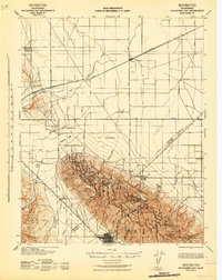
 1943 Cholame Ranch1955 Print · USGSCholame Valley and the Diablo Range are shown during the mid-1940s, a period when this rugged border region remained a remote network of cattle operations. Genealogists and historians can locate family landmarks like Jack Ranch, Maule Ranch, and Koster Ranch along the route to Cottonwood Pass.
 - 1947 Map of San Luis Obispo, 1948 Print
 1947 San Luis Obispo1948 Print · USGSCoastal California at the dawn of the Cold War reveals a landscape of massive military reservations and quiet seaside towns. Genealogists and researchers can trace the Southern Pacific rail line, old mining sites like Los Burros Mine, and local landmarks from Point Buchon to the Carrizo Plain.
 - 1948 Map of Santa Cruz
 1948 Santa Cruz1948 Print · USGSThe Central Coast and San Joaquin Valley meet in this mid-century look at the region's agricultural and military geography. Genealogists and historians can trace the paths of El Camino Real, locate family farms near Hollister, or study the footprint of the Fort Ord Military Reservation.2 unique versions available
 - 1948 Map of Bakersfield
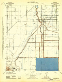
 1948 Bakersfield1948 Print · USGSBakersfield and the southern San Joaquin Valley appear in the late 1940s, showing a landscape of burgeoning oil towns, rail junctions, and early irrigation canals. Genealogists and historians can trace the foundations of local industry through Gardner Field, the Sunset Railway, and the shores of Buena Vista Lake.2 unique versions available
 - 1948 Map of San Luis Obispo
 1948 San Luis Obispo1948 Print · USGSCentral Coast life in the late 1940s is centered on the Southern Pacific rail line and expanding military bases. Genealogists can trace early rural life through Union School and local operations like the Klau Mine or Buena Vista Mine.
 - 1948 Map of Fresno
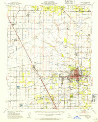
 1948 Fresno1948 Print · USGSThe San Joaquin Valley and the High Sierra met during a period of rapid post-war growth and industrial expansion. Genealogists and researchers can trace family lines through small rail towns like Calwa City, find early aviation sites at Fresno-Chandler, or locate the Fresno Copper Mine.
 - 1949 Map of Visalia, 1954 Print
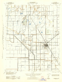
 1949 Visalia1954 Print · USGSMid-century Tulare County thrives as a concentrated agricultural powerhouse centered on the growing city of Visalia. Genealogists and researchers can trace the unique network of the Tagus Ranch worker camps or locate family sites near the College of the Sequoias and Veva Blunt Sch.2 unique versions available
 - 1949 Map of Traver, 1959 Print
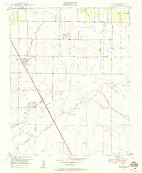 1949 Traver1959 Print · USGSAgricultural Tulare County comes into focus at mid-century as irrigation transformed the landscape around the Southern Pacific line. Genealogists can locate family holdings near Traver, London, and the Wilson Sch.4 unique versions available
 - 1949 Map of Goshen, 1971 Print
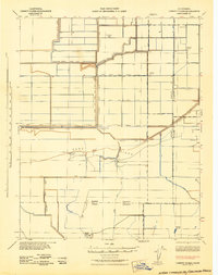
 1949 Goshen1971 Print · USGSIn the heart of the San Joaquin Valley during the mid-century, this area shows a landscape defined by industrial agriculture and complex irrigation. Genealogists and historians can trace the worker camps and rural school sites such as Camp Eleven, Manzanillo School, and Overland Ranch.
End of results
Showing maps 1-18 of 18
Top cities of Kings County
- Hanford historical maps
- Corcoran historical maps
- Lemoore historical maps
- Avenal historical maps
- Armona historical maps
- Home Garden historical maps
See more
Frequently asked questions
- What are the different types of historical maps available for Kings County?
- What is the oldest map of Kings County?
- Where can I purchase historical maps of Kings County for my home or office?
- Where can I download high-res historical maps of Kings County?
- Are there historical topographic maps available for Kings County?
- Is there historical aerial imagery available for Kings County?
- Where are historical maps of Kings County sourced from?